The Deepest Canyons In The United States
Cowboys, stampeding herds, and a beauty so immense that it drives some spectators to religion: canyons are an emblem of the grand American expanse. Despite their popularity in pop-culture, most folk can only name "the Grand Canyon" when pressed. So, let's breathe some life into public knowledge and take a look at the most unbelievably deep chasms in the USA.
10 Deepest Canyons In The USA
Infographic Showing the 10 Deepest Canyons in the US

Table Showing the Deepest Canyons in the US
| Rank | Canyon | Location | Depth (Feet) |
|---|---|---|---|
| 1 | Hells Canyon | Idaho, Oregon and Washington | 7993 |
| 2 | Kings Canyon | California | 7700 |
| 3 | Grand Canyon | Arizona | 6093 |
| 4 | Desolation Canyon | Utah | 5000 |
| 5 | Columbia River Gorge | Washington and Oregon | 4000 |
| 6 | McKittrick Canyon | Texas | 3200 |
| 7 | Waimea Canyon | Hawaii | 3000 |
| 8 | Linville Gorge | North Carolina | 2800 |
| 9 | Zion Canyon | Utah | 2640 |
| 10 | Bighorn Canyon | Montana and Wyoming | 2500 |
Understanding The Differences Between Depth, Wall Height, River Level, And Elevation Range
By definition, a canyon is a deep gorge typically between cliffs or escarpments and is often carved from the landscape by a river. To discover the depth of one section in a canyon, combine the distance between the riverbed and its immediate river surface with the distance between that same river surface and the adjacent rock wall height. When measuring for the "deepest canyon," misconceptions and confusion often arise, particularly when dealing with terms like elevation, as opposed to elevation range. For example, some surveyors might describe a vertical drop of 600 feet as a 2000 foot rise because that’s the gain that a diagonal slope's length makes up. Additionally, elevation range is simply the elevation of the most bottom floor surface, typically a riverbed, and a (likely) distant peak that is typically a canyon rim or a mountaintop in the same canyon system. This range, notably, are two distinct measurements that are conducted over thousands of square miles in these massive geological formations.
It is also important to remember that the difference in elevation between the floor and peak is not always the "depth." Maximum depth here represents the maximum distance between a floor and its nearest rim or peak, situated almost vertically above. Average depth and elevation range are alternative ways to conceptualize canyons, but they are poor metrics for identifying the "deepest" canyon. For example, King’s Canyon is often said to have a "depth" of 8200 feet, measuring from its lowest floor to maximum height. However, if those two points are separated by many horizontal miles, this measurement might not provide an accurate comparison to a canyon like Hell’s Canyon, which has a true max depth of 7993 feet, uninterrupted by diagonal measurements.
1. Hells Canyon - 7993 feet

Hells Canyon, carved by the Snake River, is the deepest river gorge in North America, reaching a depth of 7,993 feet. It straddles the border between Idaho and Oregon in the United States. The depth was sculpted over millions of years as water courses washed away layers, leaving behind towering rock faces and exposed geological layers. Its geological formation began 300 million years ago, marked by significant volcanic activity. Visitors are treated to a mosaic of alternating basalt and sedimentary rock layers, which exend across the canyon walls. The ancient rocks at the bottom of the canyon, notably the Seven Devils Mountains, date back to around 115 million years. Despite the extreme depth, the canyon floor is accessible and inhabited by various plant and animal species. The different elevation zones within the canyon further allow for distinct microclimates, hosting different species in each zone.
2. Kings Canyon - 7700 feet

Kings Canyon, with a depth of 7,700 feet, is situated within the Sierra Nevada mountains in California. It is a glaciated valley, known for its high granite peaks and steep, rugged terrain. The canyon is significantly influenced by glacial action, with U-shaped valleys and sharply carved walls. These geological features provide evidence of the extensive glacial movements that occurred in the region during the last ice age. The canyon is home to the Kings River, which has played a substantial role in its formation, cutting through the granite and shaping the landscape. The area surrounding Kings Canyon features notable elevational gradients, which support a wide array of plant and animal life, from the foothills to the alpine regions. It is also home to some of the oldest trees in the world, including ancient sequoias, signifying the longstanding ecological strength of the region.
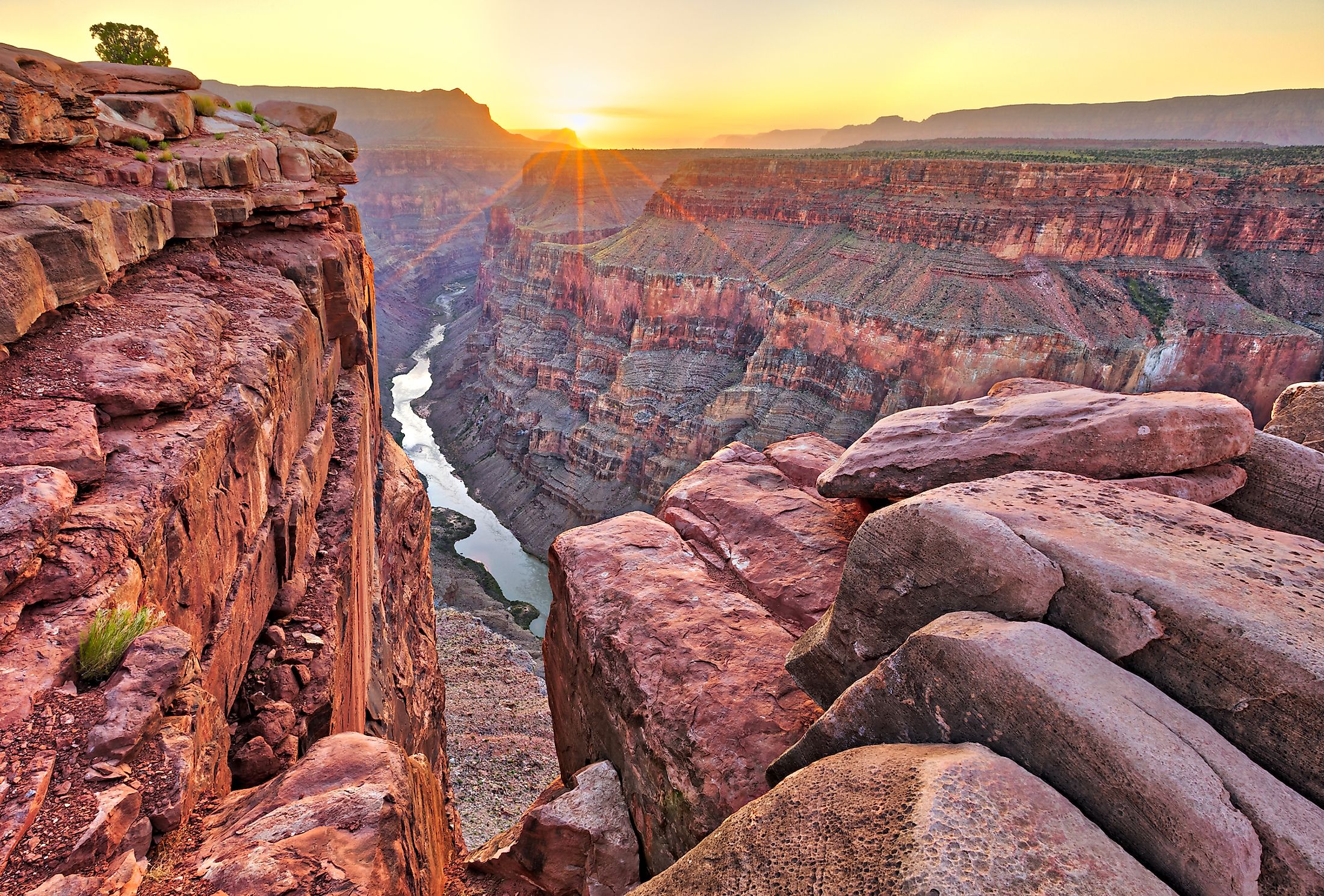
3. Grand Canyon - 6093 feet

The Grand Canyon, located in Arizona, USA, plunges to a depth of 6093 feet. This canyon has been incised by the Colorado River, which continues to erode its depth and broaden its width. The Grand Canyon is a significant geological feature, displaying a multitude of gorgeous rock layers that have been exposed by the river's erosion. These layers provide a chronological record of the past, enabling the study of geological history and the understanding of past environments, climate, and geologic events. The Colorado River has carved through various rock types, including sedimentary, metamorphic, and igneous, showcasing an extensive range of geological formations within the Grand Canyon.
4. Desolation Canyon - 5000 feet

Desolation Canyon in Utah, USA, with a depth reaching 5000 feet, is one of the deepest canyons in the United States. The canyon has been carved by the Green River, a major tributary of the Colorado River, over a timespan of millions of years. The geological process that formed Desolation Canyon involves the relentless flow of water eroding the rock, cutting deeper and exposing various rock formations. The canyon’s geology primarily consists of sedimentary rock, revealing layers of sandstone and shale laid down over millions of years. This makes Desolation Canyon an important location for studying sedimentary geology and erosional processes. Additionally, the canyon is notable for its relatively untouched and remote character, being less accessible compared to other canyons, and thus retaining much of its natural form and ecosystem.
5. Columbia River Gorge - 4000 feet

The Columbia River Gorge, with a maximum depth of 4,000 feet, separates the states of Washington and Oregon. It is a prominent geological feature formed by the Columbia River cutting through the Cascade Mountain Range. The gorge's geology reflects cataclysmic events such as the Missoula Floods that occurred around 13,000 to 15,000 years ago. These floods massively eroded the existing landscape, contributing significantly to the formation and depth of the gorge as seen today. The gorge is not uniformly deep but exhibits varying depths along its length, reflecting the different geological formations and historical events that have shaped it over time. It's an essential corridor for both human and natural activities, with significant historical, cultural, and economic relevance to the surrounding regions. The gorge’s climate varies widely, as the west end is heavily forested with an abundance of precipitation, while the east end is more arid and barren, displaying a rain shadow effect.
6. McKittrick Canyon - 3200 feet

McKittrick Canyon, with a remarkable depth of 3,200 feet, is positioned within the Guadalupe Mountains National Park in Texas, United States. The canyon is a notable geologic feature, showcasing a diverse range of rock types including limestone, sandstone, and shale. This variety provides insights into the ancient marine environment that existed here around 250-280 million years ago during the Permian period. Fossils of marine organisms such as algae and sponges are embedded in the canyon walls, marking it as an essential site for paleontological research. The dense vegetation found within the canyon includes various species of trees, shrubs, and cacti, indicative of a transition zone between the Chihuahuan Desert and the Guadalupe Mountains. The continual erosional processes by water and wind over the millennia have further revealed the internal structure of the canyon, providing a visible and accessible record of geological history.
7. Waimea Canyon - 3000 feet

Waimea Canyon, often referred to as the "Grand Canyon of the Pacific," extends to a depth of 3,000 feet on the island of Kauai in Hawaii. It is approximately ten miles long and one mile wide. The canyon was formed by the erosive action of the Waimea River, which is fueled by the high rainfall on the island's central peak, Mount Waialeale, one of the wettest places on Earth. The canyon displays a wide spectrum of colors as different layers have been uncovered, each representing a diverse geological era. The lavas of the canyon have been dated to as far back as five million years, presenting an extensive record of volcanic activity. Erosion has exposed intricate patterns in the rock, allowing for the detailed study of the island's volcanic history, making Waimea Canyon an invaluable resource for geological research.
8. Linville Gorge - 2800 feet

Linville Gorge, situated in Burke and McDowell Counties in North Carolina, achieves a substantial depth of up to 2,800 feet at certain points. Formed by the Linville River, the gorge is encased by two parallel ridges: Jonas Ridge to the east and Linville Mountain to the west, both averaging about 3,400 feet in elevation along their rims. The river itself courses for 12 miles through the Blue Ridge, contributing to the gorge's significant depth. The geological makeup of the gorge is characterized by Precambrian granitic quartzites, solidified from molten rock over a billion years ago, leading to the notable formations within the region, such as jagged spires and steep cliffs. Named after William Linville, the area also holds historical relevance, marking his demise in 1766 during an exploration expedition.
9. Zion Canyon - 2640 feet

Zion Canyon in Utah, United States, is a striking geological feature with a maximum depth of 2,640 feet. For those unfamiliar, the word "Zion" refers to the biblical conception of the Kingdom of Heaven. A man named Isaac Behunin stumbled upon this legendary tract of land in 1863 and named it appropriately, according to his Mormon faith. The canyon is part of the larger Zion National Park, a prominent destination for scientific research and outdoor activities. The canyon was principally formed by the Virgin River cutting through the reddish and tan-colored Navajo Sandstone. This erosive action led to the canyon’s deep and narrow characteristics. The rock layers of Zion Canyon tell a geological story of ancient environments, from warm, shallow seas to large desert dunes. The lowest and oldest layer exposed in the canyon, the Carmel Formation, was deposited about 160 million years ago. Sedimentary structures such as cross-bedding and ripple marks provide clues to the ancient depositional environments that existed in this region. Additionally, Zion Canyon displays the result of various other geological processes including rockfalls, landslides, and erosion from ice and water.
10. Bighorn Canyon - 2500 feet

Bighorn Canyon, carved by the Bighorn River, boasts a depth of 2,500 feet. Situated in the northern Wyoming and southern Montana, the canyon is primarily encompassed within the Bighorn Canyon National Recreation Area. The predominant geological formations in Bighorn Canyon are Cretaceous and Tertiary sedimentary rocks, which were deposited between about 37 and 145 million years ago. The force of the Bighorn River, in combination with tectonic activity, has over time carved the deep canyon into these rocks. The geological story of Bighorn Canyon is further enriched by its various tributary canyons and the surrounding Pryor and Bighorn mountain ranges. The Pryor Mountains to the east of the canyon feature an uplifted fault block of Paleozoic and Mesozoic rocks, while the Bighorn Mountains to the west are a classic example of a Laramide uplift.
Oddly enough, data for U.S. canyons (particularly regarding depth) is both rare and often opposed to competing sources. This collection took some time to narrow down, and to be certain about which canyons really can claim the title "deepest," we at WorldAtlas felt it was best to examine every canyon that exists in the country. For example, the Linville Gorge in North Carolina is not typically considered deep next to the typical top 10, but because a single section of it reaches 2,800 feet, it merits attention. Ultimately, the credit is owed to the brave explorers who have risked life and limb to measure these natural monuments, which allows us to admire them from afar.
Depth and Elevation of All USA Canyons
| Canyon | Location | Depth* (Feet) | Elevation |
|---|---|---|---|
| Hells Canyon | Idaho, Oregon and Washington | 7993 | 1,017 ft (310 m) to 7,083 ft (2,159 m)** |
| Kings Canyon | California | 7700 | 1,370 ft (0.4 km) to 14,494 ft (4.4 km) |
| Grand Canyon | Arizona | 6093 | 2,600 ft (800 m) to 9,000 ft (2,700 m) |
| Desolation Canyon | Utah | 5000 | 4,318 ft (1,316 m)*** |
| Columbia River Gorge | Washington and Oregon | 4000 | 4,000 ft (1,200 m) |
| McKittrick Canyon | Texas | 3200 | 4,997 ft (1,523 m) |
| Waimea Canyon | Hawaii | 3000 | Maximum: 3,500 ft |
| Linville Gorge | North Carolina | 2800 | 1,300 ft to 4,120 ft |
| Zion Canyon | Utah | 2640 | 4,300 ft (1,300 m) |
| Bighorn Canyon | Montana and Wyoming | 2500 | 4,488 ft (1,368 m) |
| Wind River Canyon | Wyoming | 2500 | 4,373 ft |
| James River Gorge | Virginia | 2433 | 640 ft (195 m) to 3,073 ft (937 m) |
| Black Canyon of the Gunnison | Colorado | 2250 | 5,278 ft to 8,000 ft |
| Salt River Canyon | Arizona | 2000 | 2,200 ft (671 m) to 4,200 ft (1,280 m) |
| Grand Canyon of the Tuolumne | California | 1800 | 3,957 ft (1,206 m) |
| Santa Elena Canyon | Texas | 1500 | 1,800 ft (550 m) to 7,832 ft (2,387 m) |
| Glenwood Canyon | Colorado | 1300 | 5,728 ft |
| Grand Coulee | Washington | 1300 | 1,500 ft to 2,300 ft |
| Royal Gorge | Colorado | 1250 | Unknown |
| Kolob Canyons | Utah | 1200 | 3,666 ft (1,117 m) to 8,726 ft (2,660 m) |
| Canyon de Chelly | Arizona | 1200 | 5,533 ft to 7,662 ft |
| Fremont River Canyon | Utah | 1200 | 8,819 ft (2,688 m) |
| Grand Canyon of the Yellowstone | Wyoming | 1200 | 6,181 ft to 7,215 ft |
| Breaks Canyon | Kentucky and Virginia | 1108 | 870 ft to 1,978 ft |
| Cloudland Canyon | Georgia | 1000 | 800 ft (240 m) to 1,980 ft (600 m) |
| Horseshoe Canyon | Utah | 1000 | 4,696 ft to 5,342 ft |
| Moses Coulee | Washington | 1000 | 610 ft |
| New River Gorge | West Virginia | 1000 | 745 ft (227 m) to 3,291 ft (1,003 m) |
| San Rafael River Gorge | Utah | 1000 | 5,120 ft |
| Tallulah Gorge | Georgia | 1000 | 1,568 ft (478 m) |
| Palo Duro Canyon | Texas | 800 | 2,828 ft (862 m) |
| Pine Creek Gorge | Pennsylvania | 800 | 1,106 ft |
| Rio Grande Gorge | New Mexico | 800 | 6,627 ft to 7,354 ft |
| Saint Christopher's Canyon | Puerto Rico | 800 | 2,140 ft |
| Glen Canyon | Utah and Arizona | 710 | 3,050 ft (930 m) to 7,606 ft (2,319 m) |
| Big South Fork of the Cumberland River gorge | Kentucky and Tennessee | 600 | 1,004 ft (306 m) |
| Little River Canyon | Alabama | 600 | 590 ft (180 m) to 1,780 ft (543 m) |
| Canyonlands National Park | Utah | 600 | 3,900 ft to 7,180 ft |
| Gates of Lodore | Colorado | 550 | 4,813 ft to 5,344 ft |
| Genesee River Gorge | New York | 550 | 580 ft to 1,400 ft |
| Buckskin Gulch | Utah | 500 | 4,191 ft to 4,875 ft |
| Lehigh River Gorge | Pennsylvania | 500 | 1,027 ft |
| Paria River Canyon | Utah and Arizona | 500 | 6,437 ft (1,962 m) |
| Chaco Canyon | New Mexico | 400 | 6,200 ft (1,890 m) to 6,440 ft (1,960 m) |
| Echo Canyon | Nevada | 400 | 5,200 ft (1,600 m) to 5,600 ft (1,700 m) |
| Walnut Canyon | Arizona | 350 | 6,340 ft (1,932 m) to 6,690 ft (2,040 m) |
| Niagara Gorge | New York | 322 | 300 ft to 600 ft |
| Ruby Canyon | Colorado and Utah | 300 | Peak: 11,387 ft (3,471 m) |
| Red River Gorge | Kentucky | 200 | 764 ft |
| Quechee Gorge | Vermont | 165 | 430 ft |
| Ausable Chasm | New York | 150 | 191 ft to 341 ft |
| Mississippi Gorge | Minnesota | 150 | 747 ft (228 m) |
| Providence Canyon | Georgia | 150 | 500 ft (150 m) |
| Gulf Hagas | Maine | 130 | 2,683 ft |
| Antelope Canyon | Arizona | 120 | 3,704 ft (1,129 m) |
| Provo Canyon | Utah | 120 | 4,823 ft |
| Ripogenus Gorge | Maine | 92 | 741 ft |
| Flume Gorge | New Hampshire | 90 | Peak: 4,328 ft |
| Bad Rock Canyon | Montana | Unknown | 2,910 ft (900 m) |
| Bluejohn Canyon | Utah | Unknown | 4,839 ft (1,475 m) |
| Cataract Canyon | Utah | Unknown | 3,700 ft (1,100 m) |
| Dismals Canyon | Alabama | Unknown | Unknown |
| Flaming Gorge | Utah and Wyoming | Unknown | 6,030 ft to 13,500 ft |
| Nine Mile Canyon | Utah | Unknown | 6,496 ft (1,980 m) |
| Quartermaster Canyon | Arizona | Unknown | 1,168 ft |
| Sabino Canyon | Arizona | Unknown | 2,800 ft to 3,300 ft |
| Titus Canyon | California | Unknown | Peak: 8,738 ft |
| Virgin River Gorge | Arizona and Utah | Unknown | 2,000 ft to 2,800 ft |
| Westwater Canyon | Utah | Unknown | 4,094 ft |
| Canyons of the Escalante | Utah | Unknown | 3,600 ft (1,097 m) to 11,000 ft (3,353 m) |
| Logan Canyon | Utah | Unknown | 7,828 ft (2,386 m) |
| Marble Canyon (Notable Subsection of Grand Canyon) | Arizona | Subsection of Grand Canyon/3280 ft | 2,720 ft (829 m) |
*Depth is a measurement between the floor of the riverbed and the nearest, adjacent, rim or peak.
**Ranges refer to the distance between the floor and the highest point of elevation.
***If only a single Elevation entry is present, in place of a range, it refers to the floor elevation unless it is stated to refer to the peak elevation.