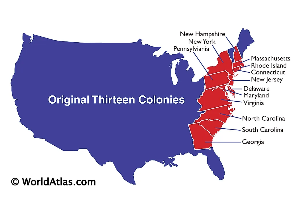
Thirteen Colonies
The British were one of the European powers who invaded and established colonies in North America. They considered the New World’s colonization a way to strengthen their powers and accumulate more resources for their homeland. Although their invasion of the continent dates back to the 16th century, The British established most of their colonies in the 17th and 18th centuries. The Thirteen British Colonies, simply known as the Thirteen Colonies, were a group of colonies established along the Atlantic coast which had similar legal, constitutional, and political systems. All the 13 colonies were part of British America, which included the Caribbean, Florida, and Canada, hence the name British American Colonies. In 1776, the Thirteen Colonies declared independence as the United States of America.
British Invasion Of North America
The invasion of North America by European powers began with the Spanish in 1565, followed by the British two decades later. The British invasion of the continent, motivated by religious, political, and economic factors, began with the Plymouth Company establishing a Roanoke settlement in modern-day Virginia. This first settlement failed terribly, partly because of the resistance from the Indigenous peoples living there. In the early 17th century, James VI granted charters to London Company and Plymouth Company to establish British colonies in North America.
In 1607, the London Company founded the Colony of Virginia as the first permanent English colony on the continent. In the same year, the Plymouth Company also established the Popham Colony near the Kennebec River, but the settlement lasted few years. The British colonies grew geographically and numerically along the Atlantic coast to 13 colonies by the beginning of the American Revolution. The settlement extended between Maine and Georgia’s Altamaha River, spreading past the Appalachians. By the time of the Revolution, the colonies hosted almost 2.5 million people. The majority of the population were English colonialists who had displaced the Indigenous populations, and people of African heritage who were brought over as slaves.

New England Colonies
Within one and a half centuries, the British had established 13 flourishing colonies with active politics and some level of autonomy. The colonies were divided into three groups: New England, Southern, and Middle colonies. The New England colonies included Plymouth Colony, Connecticut Colony, Massachusetts Bay Colony, Province of New Hampshire, and Colony of Rhode Island and Providence Plantations. The colonies are currently five of the six New England states, including New Hampshire, Massachusetts, Rhode Island, Connecticut, Maine, and Vermont.

Plymouth Colony was established by Puritan English families, today known as the Pilgrims, who landed on the Atlantic coast using the Mayflower Ship. Almost half of them died in the first winter due to harsh weather and diseases they contracted during their journey. Later, Squanto, an Indigenous person of the Patuxet tribe, taught the English how to fish and grow corn. In 1628, the Puritans, now colonialist, established a second colony in Massachusetts called Massachusetts Bay Colony. The two separate colonies merged in 1691 to form the Province of Massachusetts Bay. In 1636, Roger Williams left Massachusetts Bay Colony and established a new colony known as Providence Plantation, which merged with settlements on Rhode Island to form the Colony of Rhode Island and Providence Plantations. The same year, Thomas Hooker and his followers established settlements which later became Connecticut Colony. John Wheelwright also left Massachusetts Bay Colony in dissent and founded New Hampshire and Maine.
Middle Colonies
The Middle Colonies was a group of four British colonies that were located between the Southern and the New England colonies. The region, alongside the Chesapeake Colonies, forms the Mid-Atlantic States. The four colonies were Delaware Colony, Province of New Jersey, Province of New York, and the Province of Pennsylvania. These colonies are the basis of the current states of Delaware, New Jersey, New York, and Pennsylvania.
Initially, the Dutch occupied much of the region where the Middle Colonies were later established. The British captured the area in 1664, following a successful war with the Dutch. Most of the captured land became the Province of New York. Later, King Charles of England named part of the remaining land New Jersey, which transformed to the Province of New Jersey. The remaining land captured from the Dutch was granted to William Penn, who established the Province of Pennsylvania in 1681. The Delaware area was governed by the Duke of York’s deputy between 1664 and 1681, after which it became part of the Province of Pennsylvania. However, William Penn allowed Delaware to become a separate colony in 1701 owing to its ethnically diverse nature.
Southern Colonies
The Southern Colonies occupied the area south of the Middle Colonies and later formed part of the Southern United Starts. These colonies were known for cash crops, such as rice, indigo, and tobacco, and had the highest number of slaves than any other part of British America. The colonies included the Colony of Virginia, the Province of Maryland, the Province of Georgia, and the Province of Carolina, split into South and North Carolina in 1712. East and West Florida colonies became part of the Southern Colonies in 1763, but the Spanish later took back Florida. The Southern Colonies became the states of Virginia, Maryland, Georgia, North Carolina, and South Carolina.

Although the Province of Carolina was first chartered in 1608, the charter was considered invalid. 55 years later, a group of English noblemen known as the Lords Proprietors, led by Anthony Ashley-Cooper, were issued a new charter granting them the land of the colony and establishing the Province of Carolina in 1663. However, dissent and disquiet led to the formation of two governments in Carolina, one in North Carolina and another in South Carolina in the early 1700s. The Province of Maryland was founded by Second Lord Baltimore Cecil Calvert in 1632, becoming the first person (rather than a company) to receive a charter from the Crown.
The Colony of Virginia, established in 1607, was one of the first British colonies in North America. It was given the name “The Old Dominion” by King Charles II because it considered it a loyal colony, hence the name “Dominion and Colony of Virginia.” The Colony of Georgia was established by James Oglethorpe in February 1733 and governed by the Georgia Trustees. It became a Crown Colony in 1752, with the governor appointed by the monarch.


