8 Bizarrely Named Towns In North Dakota
Discovering North Dakota is like embarking on an epic expedition. Much like Lewis and Clark, who ventured into the uncharted heart of the Northern Great Plains, modern explorers are drawn to the state's wide-open landscapes, hidden histories, and bizarrely named towns. From the rolling hills and winding Missouri River of Cannon Ball to the storied villages near Zap or rugged badlands of Killdeer, North Dakota invites travelers to blaze their own trail, uncovering its natural beauty, Native American heritage, and frontier spirit.
Cannon Ball

Cannon Ball is a 100-square-mile town in northeastern Sioux County. It is on the Standing Rock Indian Reservation, which straddles the North Dakota and South Dakota border. The reservation, home to the Lakota and Dakota nations, covers 2.3 million acres of prairie plains, rolling hills, and buttes along the Missouri River. The town takes its unusual name from the round cannonball-shaped stones found near the confluence of the Cannonball River and Lake Oahe of the Missouri River. In "The Journals of the Lewis and Clark Expedition," Clark even notes the similarity by writing on October 18, 1804, "... in the water is a number of round stones, resembling shells and cannon balls."
There is no shortage of outdoor recreation opportunities in Cannon Ball, including watersports and fishing, and the plains provide endless hiking and biking paths. In nearby Fort Yates, history buffs can visit the Sitting Bull Visitor Center and the Sitting Bull Burial Site to learn more about the historical and cultural significance of the Standing Rock Indian Reservation and see the original burial ground of the Hunkpapa Sioux leader Sitting Bull.
Buttzville

Make no mistake; there is nothing to do in Buttzville except giggle at the town's name while looking for a rumored town sign to snap a selfie under. It was named after Charles W. Buttz, a Civil War hero and owner of the big "Buttz Bonanza Farm" he created on 36,000 acres in Ransom County in 1882. Today, Buttzville is considered a North Dakota ghost town.
Still, five miles from Buttzville, visitors can explore the small town of Lisbon in the Sheyenne National Grasslands, the only National Grassland in the tallgrass prairie region of the US. The nearby Fort Ransom State Park in the scenic Sheyenne River Valley is the perfect destination for visitors who want to stay overnight in a full-service yurt, a historic homestead with modern amenities, or a refurbished Percheron wagon.
Zap

While the precise origins of the name Zap are not known, the town of Zap may have borrowed its name from a coal-mining hamlet in Scotland but gained notoriety for the "Zip to Zap" college party-turned-riot in 1969 when between 2,000 to 3,000 students descended upon the town and the National Guard was brought in to break it up. Today, the town’s population hovers around 225 residents, but its party reputation lives on in infamy and is a pit stop for Instagrammers and college students who like to pose in front of the town's sign.
Near Zap, the Knife River Indian Villages National Historic Site is a significant cultural and historical landmark that preserves the archaeological remains of villages once inhabited by the Mandan, Hidatsa, and Arikara tribes, collectively known as the Three Affiliated Tribes. The site preserves the remnants of earth lodges, burial mounds, and artifacts such as pottery, tools, and weapons. One of the most significant finds is a former Mandan settlement, On-a-Slant Village, on the Lewis and Clark National Historic Trail.
Pingree

The small town of Pingree, which sounds funny and nonsensical, was named after Hazen Stuart Pingree, mayor of Detroit, Michigan, from 1889 to 1897. Pingree is home to the Arrowwood National Wildlife Refuge, a popular destination for wildlife viewing, birding, fishing, photography, and paddling. The nine-mile Fort Totten Trail, which runs throughout the refuge, features more than 250 species of birds, including white-tailed deer and sharp-tailed grouse.
About 20 miles south of Pingree is the town of Jamestown, well-known as the home of one of the Midwest's most popular roadside attractions: the World’s Largest Buffalo, a 26-foot-tall, 60-ton concrete giant known as Dakota Thunder. The North American Bison Discovery Center offers films, interactive exhibits, and rotating exhibits that explore the history of the American buffalo. Visitors can also view herds of buffalo or book a guided pasture tour to see the shaggy beast up close.
Killdeer

There are many theories about how the town of Killdeer earned its ominous-sounding name, including its proximity to the Killdeer Mountains, the name of the killdeer bird commonly found in the area, or the Sioux phrase "Tah-kah-p-kuty," roughly translated to "the place where they kill deer."
It was founded in 1914 at the end of the Northern Pacific Railway branch that began in Mandan. It is the gateway to the Killdeer Mountains, which feature the 6,000-acre Little Missouri State Park with 40 miles of horseback riding and hiking trails through the rugged Badlands via the Killdeer Mountains Four Bears Scenic Byway. The Killdeer Mountain Battlefield State Historic Site is accessible from the Byway and marks the site of a significant battle between the US and the Lakota Sioux led by Sitting Bull.
Pick City

Pick City, another small town with a bizarre name, overlooks Lake Sakakawea and Garrison Dam. The town was founded in 1946 and named after Lewis A. Pick, the director of the Missouri River office of the United States Army Corps of Engineers who built the Garrison Dam. At 178 miles long, Lake Sakakawea is the third largest reservoir in the United States, after Lake Mead and Lake Powell. With over 1,500 miles of shoreline (even more than the Pacific Coast of California), the deep blue Lake Sakakawea is a haven for swimmers, boaters, and anglers who will discover an eclectic menu of fish, including walleye, northern pike, chinook salmon, bass, and more year-round.
On the south side of the lake, outdoor enthusiasts will find Lake Sakakawea State Park, a popular spot for camping under the stars. The park is also the terminus of the North Country National Scenic Trail, the longest continuous hiking trail in the US at 4,800 miles. Beginning in Vermont, the trail crosses eight states before ending in the park, where hikers can access it outside the park’s Visitor Center.
Nome

As the saying goes, "There is no place like Nome," or is it "Nome, Nome on the range?" No one knows how the small town of Nome came by its moniker. Some suggest it was named after Nome, Alaska. The town was almost a ghost town (like the nearby town of Buttzville), but then someone discovered Nome's beautiful old 1916 schoolhouse.
Today, the beautifully restored schoolhouse is an event center, boutique hotel, restaurant, and artist's retreat set against North Dakota’s rolling prairie landscape, grasslands, and big sky. While in Nome, history buffs will want to look into the town's prehistoric past at Standing Rock State Historic Site, a set of four Native American burial mounds overlooking the Sheyenne River. These burial grounds or cemeteries date from 100 BCE to 600 CE and are considered sacred sites protected by law.
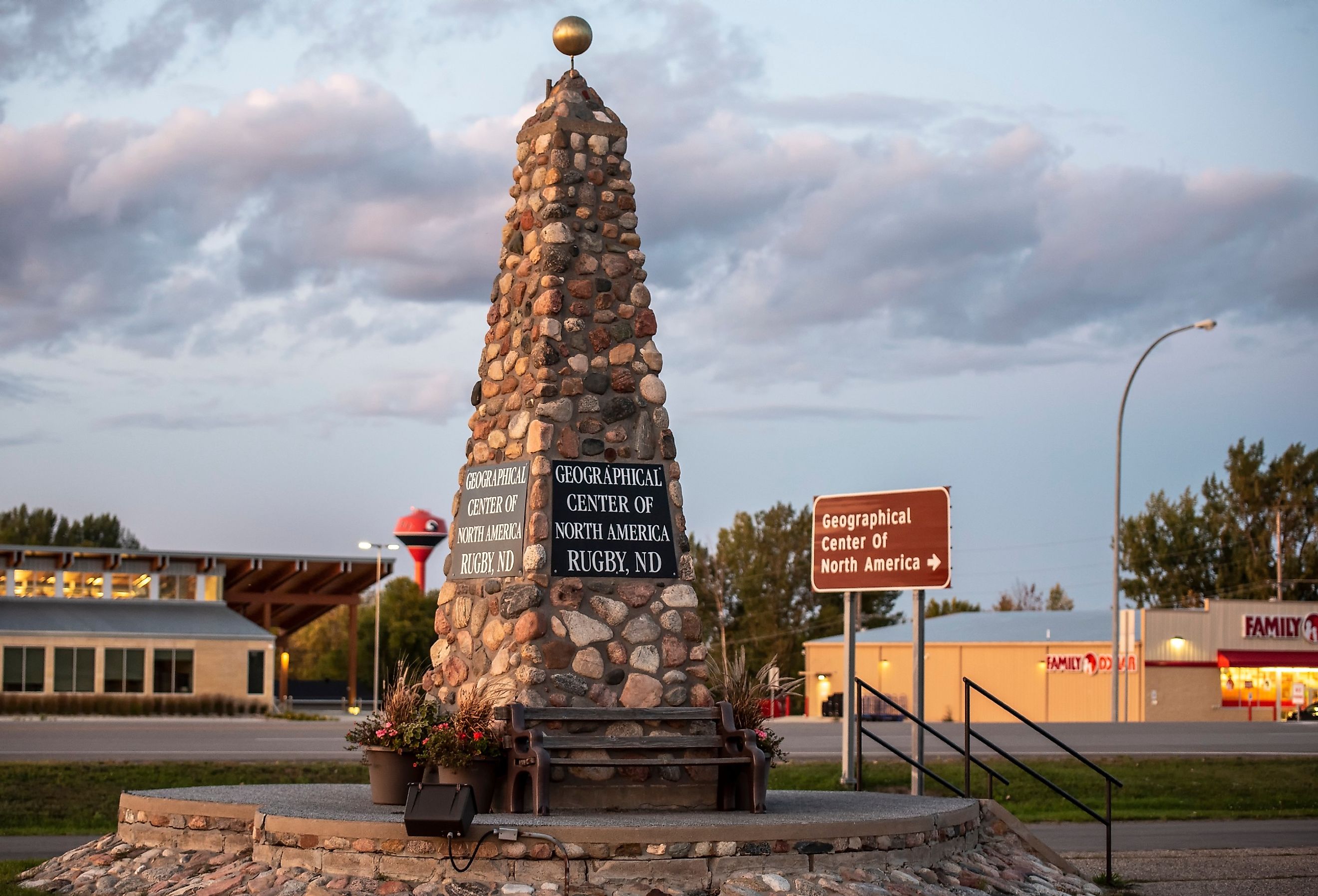
Rugby

The town of Rugby was initially called Rugby Junction thanks to its location at the junction of the Great Northern Railway, but the name comes from a town in Warwickshire, England, to attract English settlers to move to North Dakota. With a population of about 2,500 residents, Rugby is one of the state's more densely populated towns. And since 1931, a 21-foot-tall, 6-foot-wide stone monument sitting on a heart-shaped foundation in town proclaims Rugby to be the "Geographic Center of North America." While there is some debate as to whether or not this fact is true, it doesn’t matter because the designation has no official status, so why not?
Historically, Rugby has a lot going on besides its unofficial status; there is an 88.5-foot-tall steel structure dedicated to the stunning Aurora Borealis, known as the Northern Lights Tower and Interpretive Center, and a kiosk next to it that lets stargazers know more about the phenomenon. For more history about the town, the Prairie Village and Museum showcases 23 historic buildings, including the former Saint Paul's Episcopal Church, now the Victorian Dress Museum, the eye-catching Pierce County Courthouse with its dome rotunda, and the strange 30-foot-tall Niewoehner Bell Tower which contains 15 recycled bells from old churches and ghost towns.
North Dakota is full of small towns with bizarre names and curious backstories. Buttzville draws giggles for its cheeky moniker, while Nome’s origin is a mystery, though some speculate it is inspired by its Alaskan namesake. Pick City owes its name to a US Army Corps of Engineers official, and Rugby claims to be the "Geographic Center of North America." While the Peace Garden State may be one of the least populated states, these bizarrely named towns promise discovery, inviting travelers to explore its wide open spaces just as it did for intrepid adventurers over two centuries ago.