9 Off-The-Beaten-Path Towns In Southern California
Mute your GPS, switch your phone to airplane mode, and zoom in on the blank spaces between San Diego and the Mojave. That’s where Southern California hides its parallel universe, a group of hamlets where the mayor is a golden retriever! These places never bothered to court Instagram or the cruise-ship crowd; they exist on the edges of power grids and cell towers.
This article follows a loop through nine such outliers. Off-grid here doesn't mean primitive; it means precise. These communities are sharpened by isolation into one-of-one destinations you can’t mistake for anywhere else in the Golden State!
Idyllwild

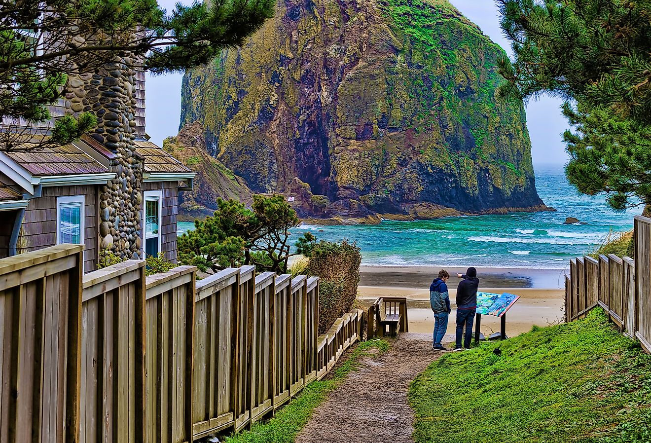
Idyllwild has no ski lifts, casinos, or corporate chains, and that absence has helped preserve its function as an artist colony and trailhead town. At 5,400 feet in the San Jacinto Mountains, it remains unincorporated and self-regulated. In 2012, the town elected a golden retriever named Max as mayor, a symbolic post that has continued with successors of the same name. The area has long attracted musicians, writers, and climbers drawn by access to granite peaks and seclusion.
The Idyllwild Arts Academy, founded in 1946, hosts public performances and gallery shows from visiting and resident artists, with studios for ceramics, metal, and Native American arts. Ferro offers wood-fired pizzas and live jazz on a tree-lined patio. Middle Ridge Winery Tasting Gallery combines local sculpture and photography exhibitions with small-lot Zinfandel and Viognier. Trail access begins at Humber Park, including the Devils Slide Trail, a five-mile route into the San Jacinto Wilderness with permits issued by the ranger station downtown. Idyllwild has no through traffic; all three roads into town dead-end or reverse, making it physically and economically insulated from larger inland cities.
Pioneertown

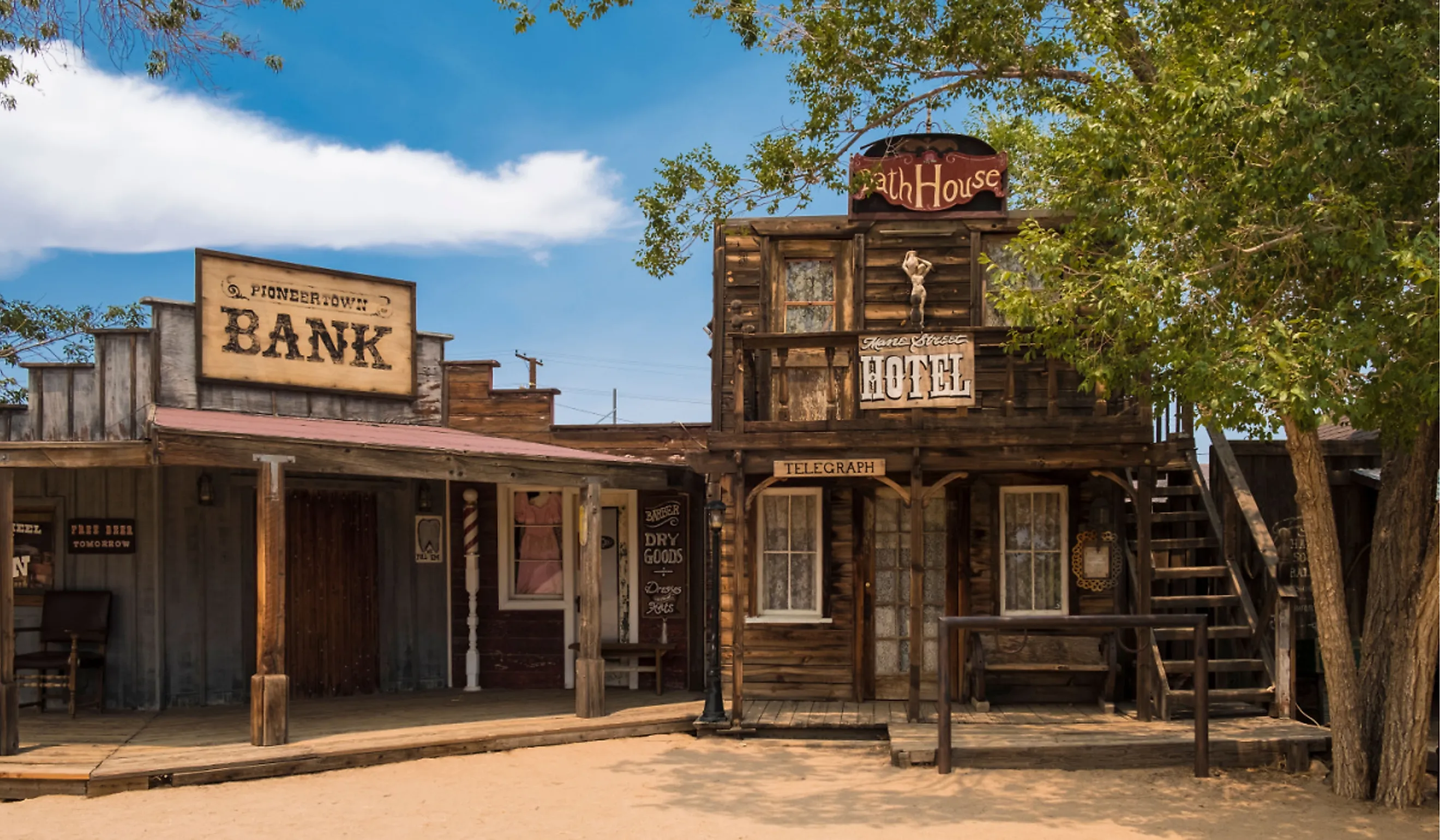
Pioneertown began as a functioning 1940s movie set, designed not just for filming but for living. It was built by a group of Hollywood investors, including Roy Rogers and Gene Autry, as a fully operational Western town where actors could film by day and sleep on site. Unlike most backlots, its facades are real structures: Mane Street is lined with hand-built saloons, stables, and jails originally constructed for films and TV shows like The Cisco Kid. Today, it operates in a strange dual reality: part ghost town and part living community.
Visitors can see a live music set at Pappy & Harriet’s, a roadhouse with a global reputation where Paul McCartney and Queens of the Stone Age have played unannounced shows. Down the street, Pioneertown Motel, once the bunkhouse for cowboy actors, now serves as rustic lodging restored with mid-century and Western details. At the Red Dog Saloon, originally built in 1946, you can eat New Mexican-style enchiladas and drink mesquite-smoked cocktails. Nearby, Pioneertown Mountains Preserve offers a stark contrast to the town’s staged history, with real desert hiking trails like Pipes Canyon that cut through Joshua tree forests and lava rock formations.
Wrightwood

Wrightwood sits inside an active fault zone where the San Andreas cuts across the San Gabriel Mountains, but it’s the town’s elevation, not its geology, that defines it. At just under 6,000 feet, it remains one of the few places in Southern California where you can downhill ski in the morning and be back in Los Angeles before sundown. Originally settled by homesteaders and apple growers, Wrightwood has kept its compact mountain-town footprint while becoming a quiet hub for snow sports and trail access.

The Mountain High Resort operates three distinct areas for skiing and snowboarding, including North Resort’s tubing lanes and terrain parks. On Park Drive, Village Grind offers breakfast burritos, espresso drinks, and live music on weekends. Grizzly Cafe, on Highway 2, serves tri-tip and house-made pies and doubles as a gathering point for locals year-round. Hikers can enter the Blue Ridge Trail directly from the town’s edge; this 2-mile climb links up with the Pacific Crest Trail and offers views over the Mojave Desert.
Jacumba Hot Springs

Jacumba Hot Springs sits on the edge of the U.S.-Mexico border with a 10-foot wall slicing through its eastern boundary and a history that predates the interstate highway system. It was once a 1920s spa destination built around geothermal wells, drawing Angelenos by rail before the rise of Palm Springs. After decades of decline, the town is being reclaimed and rebuilt—not as a resort, but as a desert outpost with an identity that revolves around art, isolation, and access to mineral water.
At the center is Jacumba Hot Springs Hotel, recently reopened with restored soaking tubs, a saltwater pool, and indoor spa facilities fed by the original geothermal source. Across the road, Gillian Gallery features installations from local and international artists, many of whom work in site using found desert materials. A short drive east leads to the Valley of the Moon Trail, which passes through volcanic boulders and overlooks both border fencing and open canyon. For food, Jay’s Southern Cafe serves fried catfish and smoked brisket in a space lined with blues memorabilia.
Trona

Trona runs on soda ash and borax. The town was built by the American Trona Corporation in the early 20th century to house workers mining evaporite minerals from Searles Dry Lake. Its high school football field is one of the only ones in the country with a dirt surface, because the local water is too briny for grass. Trona’s economy has always been industrial, but its surrounding geology has made it a consistent stand-in for alien worlds in films and research studies alike.
The Trona Pinnacles, 13 miles south, feature over 500 tufa spires rising from the lakebed, used as filming locations for Star Trek V, Planet of the Apes, and Lost in Space. Inside town, the Searles Valley Historical Society Museum displays mining equipment, aerial photos, and artifacts from company housing. The Esparza Family Restaurant serves burritos, menudo, and machaca near the corner of Trona Road and Main Street. Nearby, Valley Wells Recreation Area has a warm spring-fed pool built in the 1930s and maintained by the town’s community service district.
Ojai

Ojai bans chain stores by city ordinance. Its commercial core, built in 1917 with arcades modeled after Spanish missions, is one of the few in California where you won’t find a Starbucks, 7-Eleven, or fast food franchise. The town has long been a refuge for spiritual seekers and artists, and it maintains an independent identity tied to land use, ecological preservation, and cultural self-regulation. The surrounding Topatopa Mountains reflect pink at sunset, a light effect locals call the “Pink Moment,” visible from nearly any west-facing street.

The Ojai Valley Museum, located in a former Catholic church, documents Chumash heritage and the town’s experimental education history, including the founding of the Besant Hill School. Ojai Olive Oil Company runs tours and tastings at a working grove on Asquith Ranch Road, with a focus on estate-grown Arbequina and Koroneiki varieties. At Farmer and the Cook, a combination organic market and Mexican cafe, dishes like raw enchiladas and local beet salad rotate by season. Shelf Road Trail, accessed just north of Signal Street, winds along an old citrus-hauling path with views of the valley floor and Meiners Oaks.
Avalon

Avalon is the only incorporated city on a California island, reachable only by boat, helicopter, or private aircraft. Its harbor has served as a filming location, smuggling route, and yacht club rendezvous, but the town itself was largely shaped by chewing gum magnate William Wrigley Jr., who bought most of Santa Catalina Island in 1919. He developed Avalon as both a resort and a company town, laying out streets, building infrastructure, and commissioning the Casino, an Art Deco theater and ballroom that has never housed gambling.

The Catalina Island Museum for Art & History, relocated in 2016 to a purpose-built facility on Metropole Avenue, hosts rotating exhibits on island archaeology, the Wrigley legacy, and mid-century Catalina tile. Lovers Cove Marine Preserve, located east of the ferry terminal, is a designated snorkeling site where bright orange garibaldi swim in shallow kelp beds. Bluewater Grill, set on a pier that dates to 1920, serves locally caught swordfish and has views into the harbor. For inland access, the Garden to Sky Trail begins in the Wrigley Memorial & Botanic Garden and ascends to a ridge with views of both the Pacific and the island’s undeveloped interior. Avalon maintains logistical isolation, and that limitation defines its shape and scale.
Borrego Springs

Borrego Springs is the only California town fully surrounded by a state park. Anza-Borrego Desert State Park encloses it on all sides, restricting development and placing it under both environmental and astronomical protection. The town is a designated International Dark Sky Community, which limits outdoor lighting to preserve conditions for night photography, stargazing, and research. Power lines are buried underground. There are no traffic signals.

The Anza-Borrego Desert Natural History Association Bookstore on Palm Canyon Drive offers trail maps and desert ecology materials and organizes guided hikes into canyons and slot washes. At Carlee’s Place, a long-running bar and grill, the menu includes ribeye, patty melts, and borracho beans, with music played from an old-fashioned jukebox. The Galleta Meadows Sculptures, funded by late philanthropist Dennis Avery and built by artist Ricardo Breceda, span the open desert north and south of town; the collection includes 130 full-scale metal creatures: dinosaurs, elephants, and a serpent crossing the road. Palm Canyon Trail, beginning west of the main circle, leads through California fan palm groves to a seasonal stream fed by mountain runoff.
Julian

Julian is one of the only places in Southern California where gold, apples, and snow intersect. The town was founded during the 1870 gold rush, and when the mines declined, settlers turned to apple cultivation. Julian’s apple season still defines its calendar and commerce. The town has a designated historic district, and many of its buildings, including the blacksmith shop and livery stable, are original to the late 19th century. It is also recognized as a California Historical Landmark.
At Julian Pie Company, founded in 1986, whole pies and single slices are served daily, most use local fruit, and options include apple-berry and Dutch apple with cinnamon crumb topping. Eagle Mining Co., just off C Street, runs underground tours of an 1870s hard rock mine with working stamp mill demonstrations. For hiking, Volcan Mountain Wilderness Preserve begins just north of town and includes a 5-mile out-and-back trail with views into the San Diego backcountry and a trailhead gate built by local woodworkers and blacksmiths.
These nine enclaves prove isolation can be infrastructure. Each limits expansion through geology, ordinance, or geography, producing services scaled to residents, not revenue. Respect their constraints: bring cash, refill before leaving the freeway, and expect blackout-worthy skies after dusk. Drive slowly; livestock, hikers, and roadrunners share the pavement. If you pack out what you pack in, the towns’ deliberate stillness will remain their greatest shared amenity for future wanderers worldwide.