Nelson, British Columbia
Southeastern British Columbia is one of the most beautiful regions of Canada and perhaps all of North America. Although far less populated than its southwestern counterpart on the Pacific coast, which is home to major population centers like Vancouver, Surrey, and Burnaby, this remote corner of the province still features a healthy collection of wonderful and economically important cities. Nelson stands out as one of the most notable for a number of reasons.
Geography of Nelson

Nelson is located in the southern British Columbia side of the Canadian Rocky Mountain range, in the heart of a specific region referred to as "The Kootenays." Known for its towering mountains, deep gorges, and dense forests, The Kootenays are a wonderland for anyone looking for a beautiful escape into nature. It is about a 7-hour drive from Calgary, just across the border in neighboring Alberta, and an 8-hour drive from Vancouver. Given this distance, many opt to fly into Kelowna, the nearest major city with a notable international airport, in order to shorten the trip to Nelson (it is still about a 4-hour drive from there).
Nelson sits on the southern bank of the Kootenay River, a river that stretches 781 kilometers from Banff National Park in Alberta, snaking down into the United States through Montana and Idaho and eventually ending in the nearby city of Castlegar, where it flows into the Columbia River. The widened area of the river where Nelson is located is often called Kootenay Lake, a body of water that has been raised due to the Corra Linn Dam about 12 kilometers downriver from the city. Kootenay Lake is one of the biggest lakes in British Columbia, covering an area of 407 square kilometers.
The Selkirk Mountain range is the specific sub-range of the Rockies in which Nelson is located, nestling the city between steep rocky faces on all sides, more specifically Ymir Mountain and Toad Mountain directly on its south, and Mount Grohman across the river on its northern side.
Nelson's Climate
Nelson's position in the near center of the continent and within close proximity to the Rocky Mountains has given it what is known as a humid continental climate. This means that it has 4 distinct seasons (something that is fairly typical in Canada), with relatively snowy and cold winters and hot and dry summers. Nelson's climate and geography have made it an ideal place for both skiing/snowboarding in the colder months and outdoor activities like hiking, boating, and swimming in the warmer months of the year.
From around mid-July to September, you will see an average temperature of 82 Fahrenheit (27 Celsius) and a fairly minute 150 mm of rain. On the other hand, Nelson averages about 138 inches of snow annually, much of which falls between November and March. However, the incredibly popular Whitewater Ski Resort, which sits at a significantly higher altitude just minutes south of the city, sees an astonishing average of 40 feet of snow per year!
A Brief History of Nelson

In an area originally settled by the Sinixt and Kutenai tribes, Nelson began seeing a large influx of non-native peoples when silver and gold were discovered in its nearby rivers and hills in 1867, the same year Canada gained independence from the British Empire. When an even larger deposit of silver was discovered in Toad Mountain in 1886, Nelson's population quickly expanded and the settlement was eventually incoprated in 1897. The name "Nelson" came about in 1888 and derived from Hugh Nelson, the then lieutenant Governor of British Columbia.
Nelson was also established early on as an important transportation hub, making it easy for the resources collected in the area, such as timber and ore, to be exported abroad. Whether it was shipping on the Kootenay River or one of two major railways that eventually passed through, the ease of getting in and out of Nelson attracted many more residents. The Canadian Pacific Railway established the Kootenay Valley Railways and was, and still is, the main line that passes through the area.
Nelson's location in a narrow mountainous valley has caused most of its growth to be centered in a relatively small area on the banks of Kootenay Lake. Despite its limited size, a busy dowtown core, with Baker Street running along its heart, was built up and still features many historic buildings, including hotels, museums, and an ornate stone courthouse that has been in continuous operation since 1909.
The Population and Economy of Nelson
In its early days, Nelson's economy was heavily resource-based. Silver and gold mining originally drew immigrants to the area when major deposits were discovered in 1867 and again in 1886.
Forestry eventually became the largest and most profitable industry in the area, providing most of the jobs and income until 1984, when the local sawmill owned by Kootenay Forest Products closed permanently. This closure had a significantly negative effect on Nelson's economy, leading the city to shift its focus to other sources of profit, such as tourism and film production. By 1985, with a downtown area that had restored many of its historic structures, Nelson began transitioning from resource extraction to becoming a year-round hotspot for tourism.
As of the 2021 census, Nelson is home to a population of 11,198 residents. The city acts as the administrative center of the Regional District of Central Kootenay, making it prominent in terms of politics in southeastern British Columbia.
The median individual income in Nelson in 2020 clocked in at $38,800 (CAD) and well over half the population is between the ages of 15 and 64. Ethnically, Nelson is comprised of residents who primarily descend from European origins, with the vast majority claiming English, Irish, Scottish, French, and German ancestry, which is fairly typical in many of Canada's more rural towns and cities.
Tourism in Nelson

Nelson is well-known today for its robust tourism industry as there are several outdoor activities that one can embark on in and around Nelson during the year. Within walking distance or via a short car ride, a few notable attractions stand out.

As with many areas of western Canada, hiking is a popular activity in the Kootenays, and several notable trails are located near Nelson, the most popular of which is Pulpit Rock. This steep, stony outcrop rises 316 meters and provides what many consider the best views of the city with its unobscured outlook from the northern side of the lake looking down. The hike is a relatively short 3.5-kilometer out-and-back trail, but has a challenging ascent!
Kokanee Creek Provincial Park is located approximately 21 kilometers north of Nelson via scenic Highway 3A. It's a fantastic place to observe wildlife and enjoy the beautiful landscapes of the Kootenay Valley. The park offers a campground and a network of well-marked trails, making it easy to spend an entire day exploring. Additionally, the park is an important spawning ground for salmon in late summer. Visitors can get an up-close view of the salmon spawning by walking along the park's extensive system of boardwalks that cross the spawning streams.
For a more adrenaline-filled outing in the summer, the Kokanee Mountain Zipline is a huge draw for tourists. This attraction features 6 ziplines that span a total of 5450 feet!

Nelson and its surrounding area get a fair amount of snow in the colder months of the year, particularly in its higher elevations. The Whitewater Ski Resort draws visitors from around the world to its collection of downhill runs that accumulate over 40 feet of powdery snow per year! Just a 20-minute drive south of the city, this accessible ski area also has the nearby Hummingbird Lodge & Campground as a lodging option at the base of the slopes.
An extensive network of well-groomed cross-country ski trails can also be found nearby at both the Nelson Nordic Ski Club and the Whitewater Ski Resort.
What To Do in Dowtown Nelson

Nelson's dowtown core has gone through quite the revival since the mid-80s. Nelson Museum, Archives & Gallery features award-winning exhibitions and renowned artists from across the country. Downtown Baker Street is filled with top-notch dining spots, charming accommodations, and stylish boutiques.
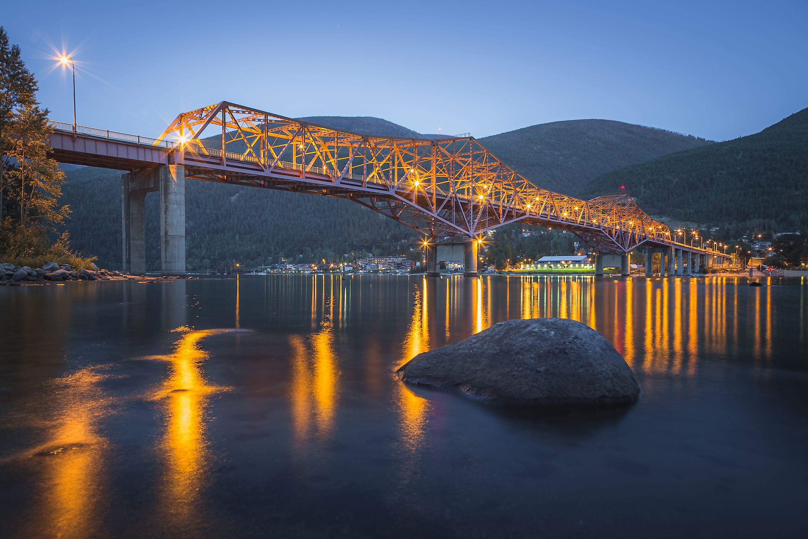
There is a large path system along the waterfront that offers excellent views of Kootenay Lake. The pathway begins at the Prestige Lakeside Resort, passes through Rotary Lakeside Park, and ends at the Big Orange Bridge—named for its distinctive orange paint and considerable size. Beneath the bridge, a sandy public beach can also be enjoyed.

Gyro Park offers another ideal outlook over Neslon. Located at the northeastern end of the downtown core, this hike is a little more accessible for those looking for a shorter and slightly easier hike than Pulpit Rock and would prefer not to have to drive to its trailhead.

Nelson exemplifies the unique and relatively remote southeastern corner of British Columbia with its quaint and inviting atmosphere and historical significance that is closely associated with some of Canada's earliest industries. In modern times it has come to be viewed more as a retreat for tourists, but a walk along Nelson's streets will show you that it still holds on to its earliest roots as an important economic center in western Canada.


