The 10 National Natural Landmarks of Arizona
The state of Arizona is located in the southwestern United States. Arizona has ten National Natural Landmarks that are recognized by the National Natural Landmarks Program. This program was created in 1962 and mandated to ensure the conservation and preservation of sites with outstanding geological and biological features. The program is run by the National Park Service and landmarks are chosen based on their rarity, value to science and education, illustrative character, and condition.
The 10 National Natural Landmarks of Arizona
Barfoot Park

Barfoot Park provides what botanists and forest ecologists consider one of the finest examples of Madrean-influenced ponderosa pine forests in the United States. Here, at elevations between 8,000 and 9,000 feet, the familiar ponderosa pines of the American West grow alongside species more typical of Mexico's high country, creating a forest community found nowhere else north of the border.
This unique forest represents the northernmost extension of the Madrean flora—a diverse assemblage of plants that originated in the mountains of central Mexico and gradually spread northward through the isolated ranges of the Sky Island region. The Chiricahua Mountains, rising like a biological island from the surrounding desert lowlands, provide the cool temperatures, summer rainfall, and varied topography these montane species require to survive so far from their tropical origins.
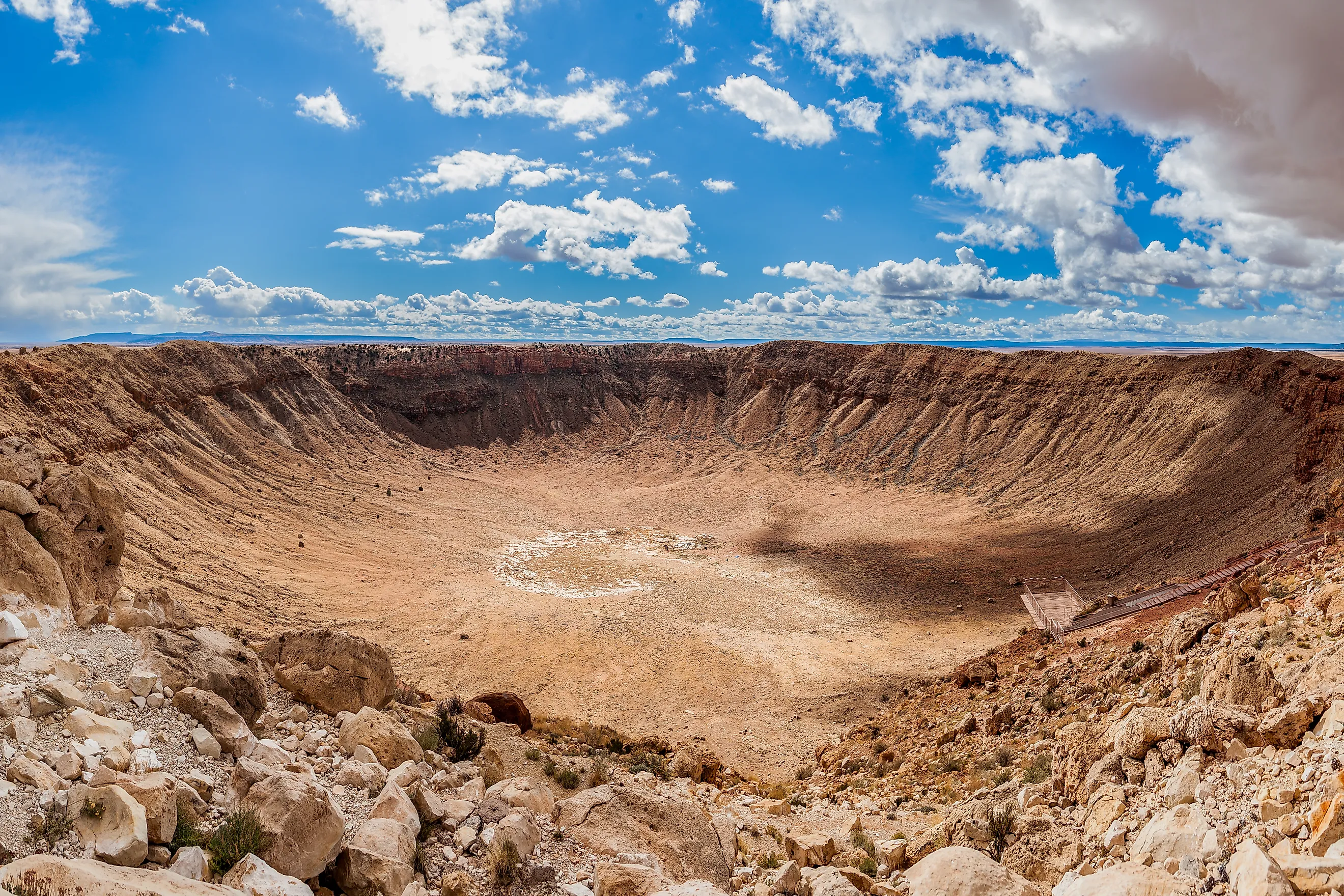
Barringer Meteor Crater

Located approximately 37 miles east of Flagstaff and 18 miles west of the historic Route 66 town of Winslow, this natural wonder tells the story of a catastrophic collision that occurred roughly 50,000 years ago. At that time, during the Pleistocene epoch when woolly mammoths still roamed North America, a metallic asteroid roughly 150 feet in diameter hurtled through Earth's atmosphere at an estimated 26,000 miles per hour.
The impact released energy equivalent to 150 times that of the atomic bomb dropped on Hiroshima. In an instant, millions of tons of limestone and sandstone were vaporized, melted, or hurled skyward, creating the nearly mile-wide crater that spans 4,150 feet from rim to rim. The force was so tremendous that fragments of the original meteorite—officially designated the Canyon Diablo Meteorite after the nearby Canyon Diablo—were scattered across the desert for miles in every direction.
Canelo Hills Cienega Reserve

The word "cienega" comes from the Spanish for "marsh" or "swamp," and these wetland oases were once scattered throughout the American Southwest like emeralds in a sea of grass. Fed by underground springs and seasonal rains, cienegas created ribbons of green that sustained both wildlife and human communities for millennia. Today, less than 10% of Arizona's original cienegas remain, making the 260-acre Canelo Hills Cienega Reserve a window into a vanishing world.
Located on the eastern slopes of the Canelo Hills, approximately 50 miles southeast of Tucson and just a stone's throw from the Mexican border, this preserve represents one of the most intact examples of a Southwestern grassland ecosystem. Here, where elevation ranges from 4,800 to 5,200 feet, cool mountain air meets desert heat, creating a unique microclimate that supports an extraordinary diversity of life.
Comb Ridge

Comb Ridge stands as one of the most impressive and accessible examples of a monocline anywhere on Earth. Beginning where it merges with the volcanic peaks of the Abajo Mountains, eleven miles west of the Mormon pioneer town of Blanding, Utah, the ridge extends essentially due south for 45 kilometers (28 miles) to the San Juan River, where it continues into Arizona for another 50 miles before gradually diminishing in the painted deserts near the Hopi Reservation.
This massive geological feature represents millions of years of Earth's history written in stone. The ridge exposes layer upon layer of sedimentary rock—red Wingate Sandstone, purple Chinle Formation, white Navajo Sandstone, and buff-colored Dakota Formation—each stratum telling the story of ancient seas, desert dunes, and river systems that once covered this region.
Grapevine Mesa

Recognized by botanists and desert ecologists as containing the finest existing display of Joshua trees in the United States, Grapevine Mesa showcases Yucca brevifolia in all its bizarre magnificence. The mesa's unique geological and climatic conditions have conspired to create what amounts to a Joshua tree paradise. Elevated above the surrounding desert floor, the mesa catches precious moisture from winter storms while providing the well-drained soils and temperature fluctuations these remarkable plants require to thrive. The result is not just individual specimens of exceptional size and health, but an entire forest community that represents the Mojave Desert ecosystem in its most pristine and fully realized form.
Kaibab Squirrel Area

The Kaibab Squirrel Area, established in 1965 and encompassing 304,594 acres of pristine high-elevation forest in Coconino County, represents one of the most focused conservation efforts in American wildlife management history. This federally-protected reserve was created with a single, urgent purpose: to preserve the only habitat of the Kaibab squirrel (Sciurus aberti kaibabensis), a subspecies so rare and specialized that its entire world population is confined to this area.Cut off from other squirrel populations by the mile-deep canyon and surrounding desert lowlands, the North Rim squirrels gradually developed their distinctive characteristics: brilliant white tails that flash like semaphores through the dark forest, prominent ear tufts that give them an almost lynx-like appearance, and subtle variations in body size and coat coloration that distinguish them from their nearest relatives just 10 miles away.
Onyx Cave

Onyx Cave covers about 50 acres in Santa Cruz County within the Coronado National Forest. Designated a National Natural Landmark in 1974, the site is managed by the federal government for its geological importance.
The cave contains a dense concentration of helictites, stalactites, stalagmites, flowstone, and draperies formed by the slow deposition of calcite. These formations, often referred to as cave onyx, show how groundwater movement shapes underground limestone systems over long periods.
Patagonia-Sonoita Creek

The Patagonia–Sonoita Creek Sanctuary covers 314 acres in Santa Cruz County and represents one of the few remaining permanent stream-bottom habitats in southern Arizona. Designated a National Natural Landmark in 1970, the site is privately owned and managed by The Nature Conservancy.
The area includes a stretch of Sonoita Creek, which supports a mix of riparian woodland, mesquite grassland, and cottonwood-willow forest. This habitat provides essential water and shelter for a wide range of wildlife, including Mexican and migratory bird species that are uncommon elsewhere in the region.
Ramsey Canyon

Ramsey Canyon covers about 279 acres in the Huachuca Mountains of Cochise County. It was designated a National Natural Landmark in 1965 for its distinctive blend of mountain and desert ecosystems. The site is privately owned and managed by The Nature Conservancy.
A perennial stream runs through the canyon, supporting a mix of oak, pine, and sycamore forest that creates cooler, wetter conditions than the surrounding desert. This environment supports a range of Mexican and southwestern plant and animal species, including over a dozen kinds of hummingbirds, the highest diversity recorded in the United States.
Willcox Playa

Willcox Playa covers about 2,369 acres in Cochise County and is managed by the federal government. Designated a National Natural Landmark in 1966, it is the largest dry lake basin in Arizona.
The flat, clay-rich lakebed holds black mud deposits that contain Pleistocene-era fossils, offering insight into the region’s ancient climate and ecosystems. During wetter periods, the basin temporarily fills with water, attracting large numbers of migratory birds, including thousands of sandhill cranes each winter.
Designation
Most of Arizona’s National Natural Landmarks were designated between 1965 and 1974, reflecting a period of active federal recognition of the state’s distinctive natural sites. The earliest, Kaibab Squirrel Area and Ramsey Canyon, were both designated in 1965, while Barefoot Park, added in 2011, is the most recent. Together, these sites highlight the range of Arizona’s landscapes—from caves and canyons to desert basins and riparian habitats.
The 10 National Natural Landmarks of Arizona
| Rank | Name | Date | County | Ownership |
|---|---|---|---|---|
| 1 | Barfoot Park | 2011 | Cochise County | Federal (Coronado National Forest) |
| 2 | Barringer Meteor Crater | 1967 | Navajo | Private (Barringer Crater Company) |
| 3 | Canelo Hills Cienega Reserve | 1974 | Santa Cruz | Private (The Nature Conservancy) |
| 4 | Comb Ridge | 1976 | Navajo | Communal lands (Navajo Nation) |
| 5 | Grapevine Mesa | 1967 | Mohave | Federal (Bureau of Land Management) |
| 6 | Kaibab Squirrel Area | 1965 | Coconino | Federal (Kaibab National Forest) |
| 7 | Onyx Cave | 1974 | Santa Cruz | Federal (Coronado National Forest) |
| 8 | Patagonia-Sonoita Creek | 1970 | Santa Cruz | Private (The Nature Conservancy) |
| 9 | Ramsey Canyon | 1965 | Cochise County | Private (The Nature Conservancy) |
| 10 | Willcox Playa | 1966 | Cochise County | Federal (Bureau of Land Management) |


