Climb Guadalupe Mountains National Park’s El Capitan Through Autumn’s Fiery Maples
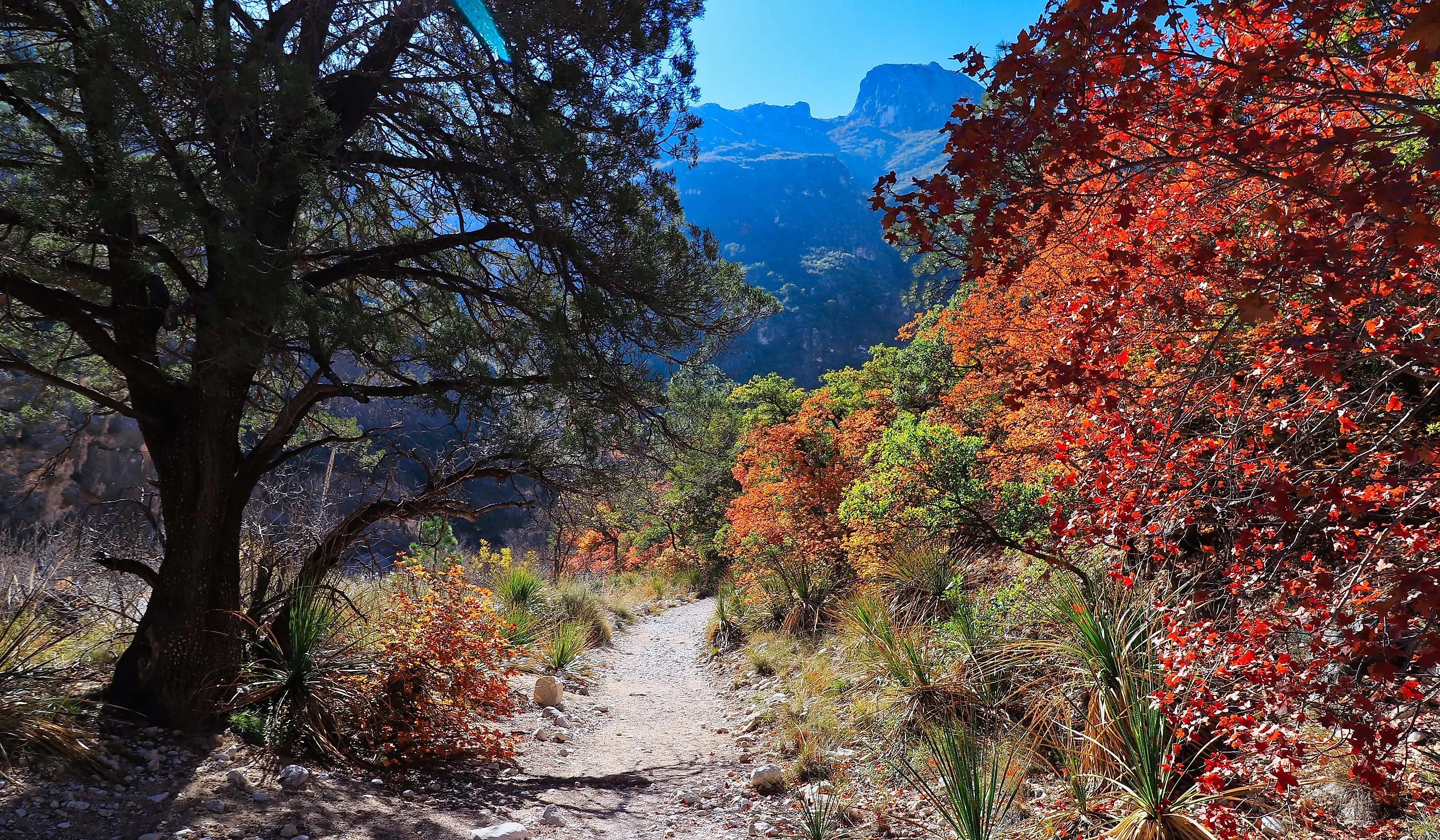
From mid-October to mid-November, the maples in Guadalupe Mountains National Park put on a dazzling display of fall colors. Everywhere you look, there are deep oranges, fiery reds, and warm golds.
There is no better way to take in this scene than from the top of Guadalupe Peak - one of the park’s standout features. When the weather is just right, with sunny days and cool but not freezing nights, the colors are even more spectacular.
Where is Guadalupe Mountains National Park?

Guadalupe Mountains National Park is located near the New Mexico border in western Texas. It encompasses several ridges and desert canyons across Hudspeth and Culberson counties, around 110 miles east of El Paso and 50 miles southwest of Carlsbad, New Mexico.
Its remote location helps to protect the core of the mountain range as it rises 3,000 feet from the Chihuahuan Desert floor. There is a primary visitor access point at an elevation of 5,400 feet, and the park’s highest summit, Guadalupe Peak, is 8,751 feet high. Highway 61 and 180 run along the southern boundary, linking Van Horn and Carlsbad.
Geography

Guadalupe Peak is not only the highest point in the park, but also in the whole of Texas. This peak and the rest of the Guadalupe Mountains lie southeast of the Sacramento Mountains and to the east of the Brokeoff Mountains.
From the peak, the mountain range extends both northeast and north-northwest in Texas and into New Mexico.
The northwestern extension extends far into New Mexico and ends near the Sacramento Mountains. To the north, the Guadalupe Mountains are bordered by Four Mile Canyon. Its western border is formed by West Dog Canyon, Big Dog Canyon, Valley Canyon, Piñon Creek, and Middle Dog Canyon. To the east, the Pecos River valley forms another border.
The mountain range consists mainly of the Capitan Reef, which was formed at the edges of a shallow sea during the Permian Period. The limestone present across the range means there is almost no surface water in the upland regions. McKittrick Creek, which lies in McKittrick Canyon, is the only area with notable surface water.
Brief History

The Guadalupe Mountains are an impeccable example of a marine fossil reef, and they continue to draw scientists and geologists from around the world. This reef formed around 250 million years ago when a tropical ocean covered today’s Texas and New Mexico.
The precipitation of algae, sponges, and other marine organisms from the ocean water, built up over millions of years alongside the marine lime. This formed the horseshoe-shaped Capitan Reef.
When the sea vanished over time, the reef subsided and was covered in layers of mineral salts and sediment. It wasn’t until an uplift exposed part of it that the reef complex towers became visible. The other parts of the reef stand in the Glass Mountains and the Apache Mountains.

The mountain range has also been the backdrop of human history for thousands of years. Archaeological evidence shows that Native American groups, including the Mescalero Apache, inhabited this landscape long before European arrival. They hunted, gathered, and took shelter in the region, enjoying its plentiful resources, including fresh spring water and mescal plants.
In the 1850s, European-American settlers and military expeditions made their way into the area. Over the years, there were several conflicts between these groups and the Apaches.
By the late 19th century, ranching was established, with the Frijole Ranch being built in the 1870s. The Smith family lived on the ranch for many decades, and the homestead still exists as a historical attraction within the park.
The idea of preserving the Guadalupe Mountains was raised in the early 20th century. However, the concept only came to fruition in 1959 when Wallace Pratt donated more than 5,000 acres of the region, including McKittrick Canyon, to the National Park Service.
More land acquisitions followed, and Congress authorized the creation of the Guadalupe Mountains National Park in 1966. The park was officially established in 1972.
Must-See Landmarks

Today, there are several striking landmarks in the park, shaped by geology and topography.
One of the most popular landmarks is the above-mentioned El Capitan. This peak was once a guidepost for travelers and settlers, but it cannot be climbed in the true sense of the word. If you want to reach El Capitan, you must first scale the area and get near the summit of Guadalupe Peak on the Guadalupe Peak Trail. Climbers who take this route must climb down from the trail to the south saddle before going along the back of El Capitan itself. El Capitan does not have a trail, so the trek from the Guadalupe Peak involves an intricate scramble over rugged terrain. Most people do not advise doing this.
It is also not advised to climb the three cliffs on the sides of El Capitan as the rock is unstable.
Guadalupe Peak also makes for a fantastic hike, with an 8.4-mile round-trip trail that offers panoramic views of the Chihuahuan Desert.

At McKittrick Canyon, you will find the foliage the park is so famous for, with the McKittrick Canyon Trail leading to historical landmarks including Pratt Cabin and the Grotto, located right inside the changing maples, oaks, and ferns.
There are more trees in The Bowl, which is a high-elevation forest basin that supports an island of Douglas fir and ponderosa pine. These confiners are not widespread in desert environments, making them a wonderful sight in the park. Keep in mind, however, that the hike to The Bowl can be strenuous when you take the Bowl or Tejas Trails.
Natural Phenomena

The most celebrated phenomenon in the park, aside from the striking peaks, is the bigtooth maples in their fall colors. The maples ignite the landscape with their deep russet and orange tones. McKittrick Canyon, also called ‘the most beautiful place in Texas,’ is where these colors really shine. You will find maples, oaks, and ash trees thriving along a seasonal stream and glowing in the desert sun.

The Guadalupe Mountains National Park is also a great location for stargazing and is a designated International Dark Sky Park. There is minimal light pollution, so on clear nights, you can see the Milky Way stretching across the night sky in dazzling clarity. The Perseids and Geminids meteor showers can also be seen here, especially from the Guadalupe Peak or Salt Basin Overlook on a crisp fall evening.
The Animals of Guadalupe Mountains National Park

Even though the desert environment is harsh, the mountaintop forests and streamside woodlands in the park create suitable habitats for 60 mammal species, around 289 bird species, and 55 reptile species.
It is not always easy to spot the park’s animals, as many desert animals are nocturnal. These nocturnal dwellers include bobcats, coyotes, mountain lions, badgers, and kit foxes.

While exploring the park, you may see mule deer, jackrabbits, and javelinas, and you should keep a very wide eye out for rattlesnakes and scorpions.
Along the riparian woodlands, skunks and raccoons roam, and sunfish inhabit the springs. Inside the canyons are rock squirrels, ringtails, and tree lizards.
Where the pine forests grow 3,000 feet above the desert, they provide a habitat for elk, gray foxes, and black bears, which enjoy the cooler weather.
Things to Do

The Guadalupe Mountains National Park is a dream destination for a desert adventure. However, it means a lot of walking and hiking, since there's not much to see from a vehicle.
If you are visiting solely for hiking, climbing to the top of Guadalupe Peak is a must-do. Another strenuous hiking option is the 3.75-mile Devil’s Hall Trail, which starts at the Pine Springs Trailhead. Keep in mind that the first mile or so is easy, but the rest is very rocky, with big boulders you will have to clamber over.
The Hunter Peak Loop also starts and ends with the Pine Springs Trailhead, with most visitors hiking the Bear Canyon Trail to the Bowl Trail. From here, it is downhill along the Tejas Trail.

The Pinery Trail is much easier to complete, since it is paved and takes only thirty minutes to do. The Smith Spring Trail Loop takes around 2 hours and leads ot the Smith Spring. You can also visit the Frijole Ranch Cultural Museum, which once formed part of the Frijole Ranch.
Along the McKittrick Nature Trail, you can read the signs identifying the plants and animals in the region while enjoying the views of the canyon and the Permian Reef.
Other activities to enjoy in the park include seeing the dunes on the west side of the park and learning more about the Butterfield Stage Coach Route.
It is important to note that if you want to spend more than a day in the park, there are no hotels or lodges within its boundaries. You will, however, be able to camp at Pine Springs or Dog Canyon inside the park.
For more formal accommodation, you will have to look at places in Van Horn or Carlsbad. Motel 6 in Van Horn is a comfortable, affordable option, while the Carlsbad RV Park and Campground comes with cabins, games, and a pool.
The best time to visit the park is during the spring when the temperatures are mild or in the fall to see those stunning fall colors. You’ll also find fewer crowds as you take in the spectacular views. So, get out those hiking boots, fill up your water bottle, and take a trip to one of the most unique and beautiful national parks in the U.S.