
11 Most Scenic Road Trips to Take in The Southern United States
The beauty of a country with 50 states is its diversity. You can travel for one hour and feel you have stumbled back in time ten years, or even find yourself roaming an extra-terrestrial-like land and only figuring out directions once you ask a seaside-shack local. That is the intrigue of the mighty American road trip that millions set their vacation time on every year. There is a little bit of everything in the Southern United States, from leaf-peeping vibrant colors on the Blue Ridge Parkway to the ocean views along the Overseas Highway. These are among the most scenic road trips in the Southern states, so no scenic byway and quintessential multi-day natural and cultural experience is missed for any adventure-seeking travelers.
Blue Ridge Parkway (Virginia, North Carolina)

Blue Ridge Parkway, the longest linear parkway in the country, is "America's favorite drive." It is 469 miles (755km) long, and it connects to major national parks: the Shenandoah National Park in Virginia and the Great Smoky Mountains that extend from North Carolina into Tennessee. The 360-degree views of the Appalachians are accented in the fall by the overwhelming lushness of yellow and red leaves, making it a fall favorite for tourists. The speed limit is set at 45mph for most of the route, so all drivers have the same goal: enjoy. Plus, obstructions to your view, like commercial trucks and billboards, are banned. If you plan your trip well, you can start (or end) with the equally beautiful Newfound Gap Road Byway.
Newfound Gap Road Byway (North Carolina, Tennessee)

This 31-mile byway is totally within the boundaries of the Great Smoky Mountain National Park. Aside from its stunning views, you can stay overnight in culture-rich getaways like Leconte Lodge, built in 1926, and rest in scenic backcountry by the park's third tallest peak, Mount LeConte. If you finish the byway and still want to go higher, you can visit the highest peak in the Smokies, Clingmans Dome, and its observation tower for a dramatic panoramic view. For a ground-level trail to stretch your legs, continue to the peaceful serenity of the Oconaluftee River for a 3.1-mile (5km) out-and-back walking trail featuring shallow, calm rolling waters.
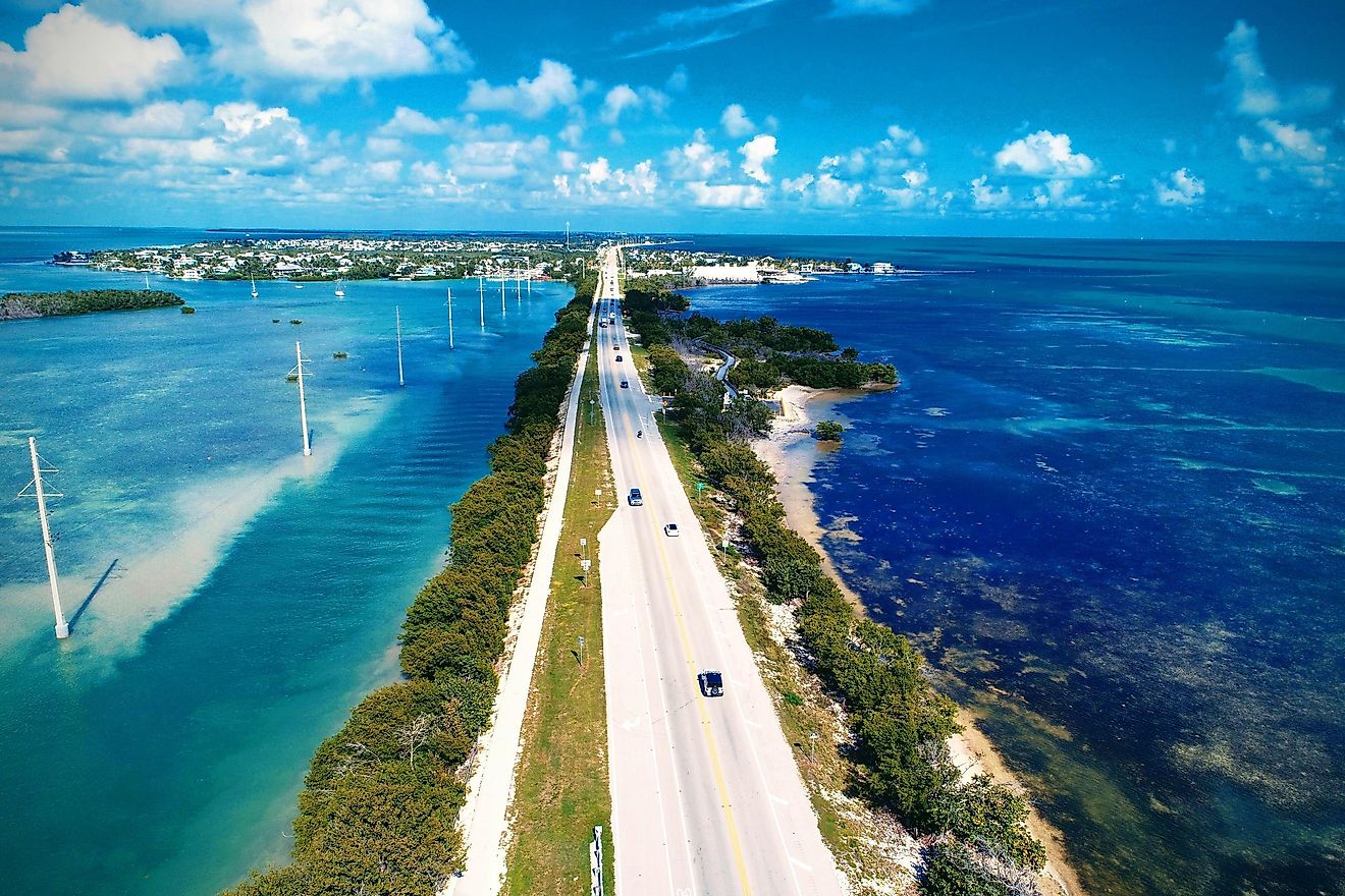
Overseas Highway (Florida)

This is the iconic "Highway that Goes to Sea." This road is 113 miles (182km) long and starts from the main island of Key Largo and extends through the islands of Islamorada, Layton, Duck Key, Big Pine Key, and finally, Key West. The drive is views of warm blue water and pure sandy beaches accented with small patches of lush green land. You pass oceanfront villas, tall palms and flowering plants, fine seafood restaurants, sportfishing fleets, and sailing yachts, all the while taking in the crisp tang of saltwater air. Stop at the marine sanctuary of Bahia Honda State Park, renowned for its snorkeling and kayaking. To complete your southern Florida experience, you can start your trip in Everglades National Park, only about 37 miles from Key Largo.
Ozark Highlands Scenic Byway (Arkansas)

This byway is only 35 miles (56km) and takes an hour to cross but leaves a lasting impression. Start in the southern portion of the Ozark National Forest in Clarksville, Arkansas, along the majestic Arkansas River Valley. Continue north on the Arkansas State Highway 21 and find the Upper Buffalo Wilderness to take a 3-mile out-and-back walking trail to the iconic view at Whitaker Point (also known as Hawksbill Crag), once dubbed "the best place in Arkansas to get kissed." Take another stop at Buffalo National River, where nature lovers dip their feet in the clear water, set a line for fly fishing, and marvel at the dramatic stone cliff backdrop.
Outer Banks Scenic Byway (North Carolina)

The Outer Banks Scenic Byway runs through stunning coastal landscapes and seascapes and passes 21 unique maritime villages on the way. The trip includes 138 miles (222km) of driving and 25 miles (40km) of ferry riding along the route's nine barrier islands (or banks). There are national wildlife refuges like Pea Island and Cedar Island featuring calm, cool ocean air and sounds and occasional turtles, and two national seashores, Cape Hatteras and Cape Lookout, for enjoying long stretches of sand dunes, marshes, and unique maritime forests. Despite all the natural beauty, most visitors note that the uniqueness of this byway lies within the various coastal villages where chain stores don't exist, and small local businesses and a small-town sense of charm hold a strong sense of community together.
Tail of the Dragon and Cherohala Skyway (Tennessee)

The Tail of the Dragon, bordered by the Great Smoky Mountains and the Cherokee National Forest, is the pinnacle of motorcycle and sportscar riding for an adrenaline-pumping and scenic drive. The road is winding: it takes 318 tight turns within 11 miles (17.7km), so be cautious and clear your mind, knowing that there are no intersecting driveways or roads along the way.
The reward at the end is the breathtaking Cherohala Skyway: a remote 60 miles (96km) of forested mountainside with refreshing waterfalls and long, sweeping bends starting in Tellico Plains, Tennessee. Enjoy the scenic overlooks as you pass through the Cherokee and Nantahala National Forests.
Canyon Sweep (Texas)

A drive-through Canyon Sweep is a dusty, barren landscape of hills and flatlands made of layers of red rock and soil that are accented by sparse low-foliage, like cacti or shrubs. Then the road continues on, and there are impressive canyons, capitalized by Palo Duro, "the Grand Canyon of Texas," the second-largest canyon in the United States: 120 miles (193km) long and up to 20 miles (32km) wide. Below is the Red River, one of the longest rivers in North America, carving through the red rock. Along the way, you can stop at the Lighthouse Trail and experience the red desert first-hand on the ground.
Russell-Brasstown National Scenic Byway (Georgia)

The Russell-Brasstown Byway is 40 miles (64km) of winding forest roads diving through the Chattahoochee National Forest. This drive is recommended in the fall when the large tulip and oak trees are ripe in red, orange, and yellow colors. There are several short hikes off of the main road, including the popular Raven Cliffs Falls trail that follows a tumbling trout river through a moss forest and ends in massive rock cliffs. Follow Russell-Brasstown all the way to Brasstown Bald Park and see the rolling hills of forests from the wooden observation tower at the highest point in the North Georgia Blue Ridge Mountains at 4,784 feet.
Chesapeake Country (Maryland)

There are 419 miles (674km) of road that travel along Maryland's Chesapeake Country and give a great taste of coastal villages, salt air, and picturesque farms. Starting in Chesapeake City, the route is flexible, with many options to meander along the Eastern Shore. Alternatively, start in Havre de Grace and see the shining Susquehanna River before continuing down through Baltimore to Annapolis with its old bricked streets and pretty stores. Then, cross the ocean over the William J. Preston Memorial Bay Bridge and pass through the Kent Narrows to the Delmarva Peninsula and the comfort of Eastern Shore Chesapeake living. Turn South along the Ocean Gateway Highway and take in the town of Easton's Victorian and colonial charm, continuing over the Choptank River and arriving in Cambridge, a maritime town featuring some of the best wharf-sunsets in the country. Keep straight and find a life away from town at the Blackwater National Wildlife Refuge for nesting eagles, thick foliage, and impressive sunset skylines.
Talimena National Scenic Byway (Oklahoma)

Talimena Drive is 54 miles of road designed specifically by the US Department of Transportation to cut through southeast Oklahoma in the most beautiful route possible. The drive takes you along crests of forested peaks between Talihina, Oklahoma, and Arkansas, especially colorful in the fall season when the trees are washed in red and gold. A main attraction is the density of wildlife in Ouachita National Forest, accessible to all through the Winding Stairs Trail: a 2-mile (3.2km) segment of the Little Missouri Trail that features soft, rolling waters, thick treelines, and fantastic birdwatching opportunities. Plus, the Cedar Lake Recreation Area offers outdoor activities suitable for whole families.
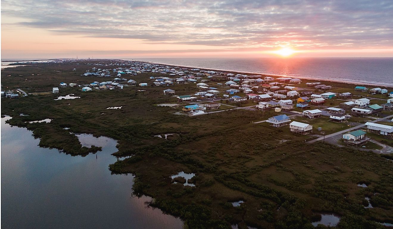
Gulf Coast Drive (Louisiana, Mississippi, Alabama, Florida)

Gulf Coast Drive is the ultimate road trip: 3 days and 700 miles (1126km) through Route 90 and Route 98 from New Orleans to South Walton, Florida. If you pass the culture and excitement of New Orleans, stop at the Maurepas Swamp Wildlife Management Area for a unique wetland experience before you leave Louisiana. See the Gulf Coast Gator Ranch in Moss Point, Mississippi, and take an airboat tour through the swamp. Have an ocean swim at Gulf State Park in Orange Beach, Alabama, and use the park's many car-camping sites. Continue on to Choctawhatchee River Water Management Area and have one of the most unique swims in the country in the large floodplain forest with bright blue water.
It is no easy decision picking between the vast barren and dramatic wastelands of desert Texas, the forested hills of North Carolina and Tennessee, and the flooded plains of Mississippi and Florida. While there is a lot to do, be sure not to rush; each route is best when you are in a serene and light peace of mind. Take a breath and enjoy the beautiful Southern United States.


