7 Best Road Trips to Take in Wyoming
Road trips are a summer vacation classic, and a time-honored American tradition. For those heading out west, Wyoming is the state that’s home to Yellowstone National Park, the Rocky Mountains, and some of the country’s cutest small towns. Wyoming is also the 10th largest state in the US, giving you a lot of ground to cover when taking to the open road. These scenic drives allow you to see the best of the state’s incredible natural beauty and inviting communities. From discovering your inner cowboy on the Buffalo Bill Byway to traversing the Oregon Trail, it’s time to saddle up and hit the road!
Bridger Valley Historic Byway

Wyoming’s Bridger Valley in the southwest of the state has seen a lot of history. The Oregon, California, and Mormon Trails, the Pony Express, the first Transcontinental Railroad, and the Lincoln Highway have all traveled through this stunning landscape. Discover it for yourself on the Bridger Valley Historic Byway, a 20-mile loop. Begin in the historic town of Lyman, founded in the 1890s by Mormon settlers. Off Interstate 80 at Exit 34, in Lyman, you can refresh on snacks and supplies. Then, check out the Bridger Valley Heritage Museum to learn more about the area.
Back on the route, you pass through the small town of Urie, and loop down to Mountain View before arriving at Fort Bridger, home to Fort Bridger State Historic Site. The site was established as a fur trading post in 1843 before becoming a wagon resupply stop on the Oregon, California, and Mormon Trails. Today you can wander the 37 acres of grounds to explore 27 historic structures, dating back to the mid-1800s, and four historic replicas. Take a self-guided tour, browse the museum exhibits, or enjoy a living history demonstration before getting back on the road. The Bridger Valley Historic Byway ends as you rejoin Interstate 80 at Exit 48.
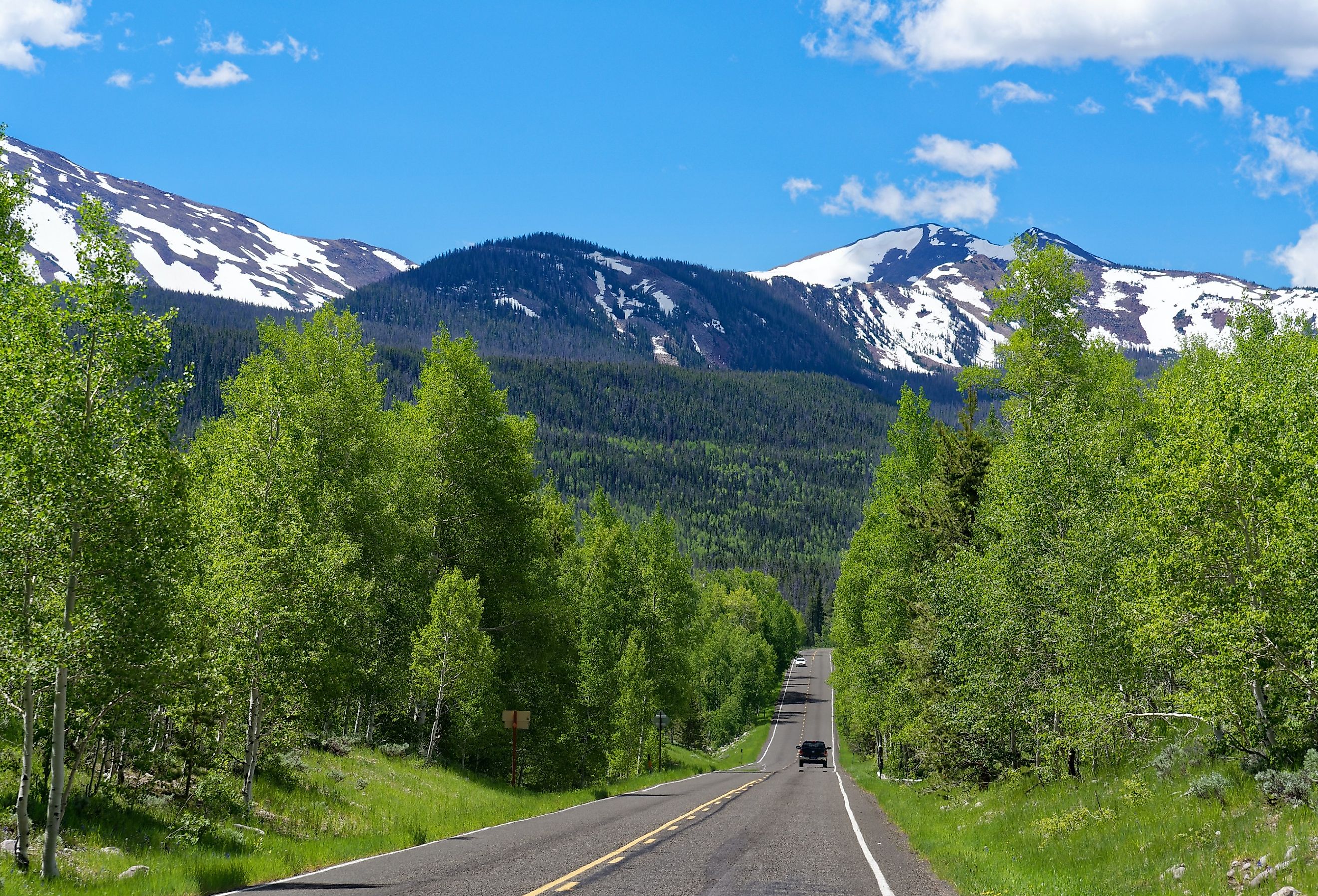
Buffalo Bill Cody Scenic Byway

If you do one road trip in Wyoming, it has to be the 27 mile Buffalo Bill Cody Scenic Byway. This legendary route takes you through the heart of cowboy country, starting on US 14/16/20, west of the town of Cody, and ending at the east entrance of Yellowstone National Park. You will see stunning scenery along the way with a starting point on the border of the Shoshone National Forest, and the route through the gorgeous mountain landscape of the Shoshone Canyon and Wapiti Valley.
Keep your camera ready, this area is known for its diverse wildlife — elk, moose, mountain goats, buffalo, and even bears often make an appearance. Notable stops along the byway include the Buffalo Bill dam, reservoir, and state park. The dam, the highest in the world when it was constructed in 1910, created the man-made lake, known as one of the best places to windsurf in Wyoming.
The park also contains plenty of tranquil fishing, swimming, and hiking spots, ideal for taking a break from the road and enjoying a quick picnic. As you continue west towards Yellowstone, you will notice some unusual rock formations with names like ‘Chimney Rock’ or ‘Holy City’. Closer to the park, you will come across Buffalo Bill’s ancient hunting lodge, the Pahaska Teepee — Pahaska was Bill Cody’s Indian name. The Buffalo Bill Scenic Byway is open year-round however the Buffalo Bill Dam Information Center is closed over the winter. The East Gate into also Yellowstone closes for the winter, shutting on the first Monday of November.
Snowy Range Scenic Byway

Formed over 2 billion years ago, Wyoming’s Snowy Range Mountains are jaw droppingly majestic. Climb up and through the towering white-capped peaks along this 29-mile scenic byway that travels from prairies and wildflower meadows into old growth forest and dazzling alpine tundra. The highest point of the drive is over 10,000 feet above sea level, providing incredible views of southeastern Wyoming. Traversing the state’s second highest mountain pass, the scenic byway can be closed due to weather so be sure to check before you hit the road.
To join the drive, take the Laramie Exit off Interstate 80. This leads you through Laramie and onto the tiny town of Centennial, where the byway begins. Here you'll find the Nici Self Historical Museum. Housed in the 1907 Centennial Railroad Depot, this fascinating museum displays artifacts and exhibits from the American West and early industry in Wyoming. From Centennial, the byway heads west, past notable stops such as the Sugarloaf Recreation Area where you can take a dip in alpine lakes or hike Sugarloaf Mountain and Medicine Bow Peak.
Don’t miss the views at Libby Flats observation point, an elevated plateau with incredible panoramic vistas. You will find more picture-perfect shots at Lake Marie, a glacier-fed lake popular with photographers. In the early summer months, bacteria feed on the lakeside snow, turning it a striking pink color. The byway ends just after Ryan Park, a small community in Carbon County that's a popular snowmobiling destination thanks to its scenic trails.
Cloud Peak Skyway

From the southern snowy mountains to Wyoming’s northern peaks, the Cloud Peak Skyway is a 45 mile stretch along US 16 which gets drivers up close to the breathtaking Bighorn Mountains. Join the drive west of the historic town of Buffalo, whose quaint downtown looks like a Western movie set. Stop into Buffalo for refreshments and to see the iconic Occidental Hotel and Saloon, originally built in 1908 and restored into a thriving hotel, restaurant, and shop.
Outside Buffalo, the twisty skyway snakes up the peaks, climbing by mountainside meadows, through deep canyons, and up to the highest point at the 9,666 foot Powder River Pass where you can pause a moment to take in the magnificent views and fresh alpine air.
The Cloud Peak Skyway skirts along the edge of the Bighorn National Forest, a nature-lovers paradise with plenty of beautiful picnic spots for a quick break from the road. If you are walking the trails, be vigilant — you are sharing the park with bears, mountain lions, and moose! The drive ends at the charming tiny town of Ten Sleep which takes its name from its early history as a rest stop for weary pioneers. Ten Sleep is 10 days travel from Fort Laramie to the south and Yellowstone to the west.
Oregon Trail Historic Byway

Before well-paved roads, airplanes, and comfortable vehicles, traveling west meant piling your family and worldly goods into a wagon and heading off into the unknown. From 1849 to 1852, over 150,000 brave souls took to the Oregon Trail to see what lay between Missouri and Oregon. That same spirit of adventure inspires tourists today on the Oregon Trail Historic Byway, a 57-mile drive alongside the North Platte River through southeast Wyoming.
The route starts on US 26 near the Wyoming/Nebraska border and ends where US 26 meets Interstate 25 at Dwyer Junction. The first city stop is Torrington, where you can see the area's first automobile, a one-room schoolhouse, and a settler's shack — all on display at the Homesteaders Museum.
From Torrington, the byway passes through the small town of Lingle and continues northwest to Fort Laramie, where you'll find the Fort Laramie National Historic Site. Built in 1834, the fort still has 22 of its original structures and regularly hosts special events on the grounds. After Fort Laramie, the drive passes through beautiful scenery to Guernsey, home of the Register Cliff Monument where you can see inscriptions left by the original Oregon Trail pioneers who scrawled names, dates, and messages into the sandstone cliff.
Mirror Lake Scenic Byway

Running from Evanston, Wyoming, right across the border into Utah, the Mirror Lake Scenic Byway on Highway 150 is a 78 mile route that’s simply stunning all year-round. In fall, enjoy the autumnal colors of the dense mixed forest lining the highway, in spring and summer the blooming wildflowers provide a scenic backdrop to the roaming deer and antelope, in winter the snow-capped peaks of the Uinta Mountains are visible in the distance.
Pick up the route in Evanston after taking a few hours to explore the former railroad town that’s leaned into its history with numerous downtown heritage sites and historic walking tours. Top attractions in Evanston include the Chinese Joss House Museum, constructed in 1874, which details the contribution of Chinese immigrants to the area from the 1870s to the 1930s.
Traveling south out of Evanston on Highway 150, you will pass the Sulphur Creek Reservoir, a full-season recreation destination with excellent fishing, boating, wind surfing, and skiing. Make time to stop at Mirror Lake once you have crossed the border into Utah. The hikes around this alpine lake offer incredible views of the landscape and the wildlife. The Mirror Lake Scenic Byway ends in the town of Kamas, Utah.
Battle Pass Scenic Byway

This 57 mile road trip winds through the Sierra Madre Mountains and Medicine Bow National Forest, promising heart-stopping scenery at every twist and turn. The route begins on Highway 70 in the town of Encampment and follows the highway west, until it ends at Baggs. In the mid-1800s this region was alive with optimistic prospectors, making their fortunes in the copper mines. Now its history is on full display with stops such as the Battle ghost town, an abandoned mining and logging community.
You will also pass the Edison Monument which marks the exact spot where Thomas Edison had his ‘lightbulb’ moment, dreaming up the idea for a filament light bulb while fishing on Battle Lake. The most impressive moment on the byway though is its namesake, Battle Pass. At nearly 10,000 feet above sea level, the pass offers sweeping views of the Sierra Madre peaks.
Wyoming’s Best Scenic Drives
There is no better way to get to know a state than traveling its scenic highways and byways. Wyoming is one of the best states to explore by vehicle with ever-changing landscapes, historic ghost towns, and welcoming communities dotted along these breathtaking routes. The state’s scenic drives are all well-marked — just look for signs with an Indian Paintbrush logo, Wyoming’s state flower. Conditions can vary so be sure to double check your routes before you set out. Some of the more mountainous highways and attractions are closed in winter or adverse weather conditions. Whether it is your first visit to Wyoming or your 51st, you will see the state in a whole new light as you cruise the roads, ready for whatever adventure is around the bend.


