9 Best Road Trips to Take in Illinois
Illinois, often known for its large cities like Chicago, has much more to offer for those seeking a scenic and historical road trip. Stretching from the Great Lakes to the Mississippi River, Illinois has a variety of landscapes, from rolling farmlands and dense forests to winding rivers and ancient mounds. Its history, deeply tied to the rivers that border and cross it, along with its role as a major transportation hub, has left the state dotted with landmarks that span centuries. From the prehistoric civilizations at Cahokia Mounds to the historic significance of Route 66, these are the nine top road trips to take in the Prairie State.
The Great River Road

The Great River Road in Illinois is part of a much larger route that follows the Mississippi River from its headwaters in Minnesota down to the Gulf of Mexico. The Illinois portion begins at the state’s northern border near East Dubuque and winds its way south to the junction with the Missouri border near Cairo. This picturesque drive spans roughly 550 miles, tracing the river's path and offering a direct connection to nature and small-town life along the Mississippi River. It’s a journey that typically takes two to three days, depending on how long you spend exploring each stop along the way.
Galena is an essential stop, home to the Ulysses S. Grant Home and a well-preserved 19th-century downtown along the Galena River. Further south, Pere Marquette State Park near Grafton has striking overlooks and hiking trails at the confluence of the Illinois and Mississippi Rivers. Cairo, once a vital river town, is the place where you'll find the Customs House Museum and Fort Defiance Park, where the Mississippi River and Ohio River meet.
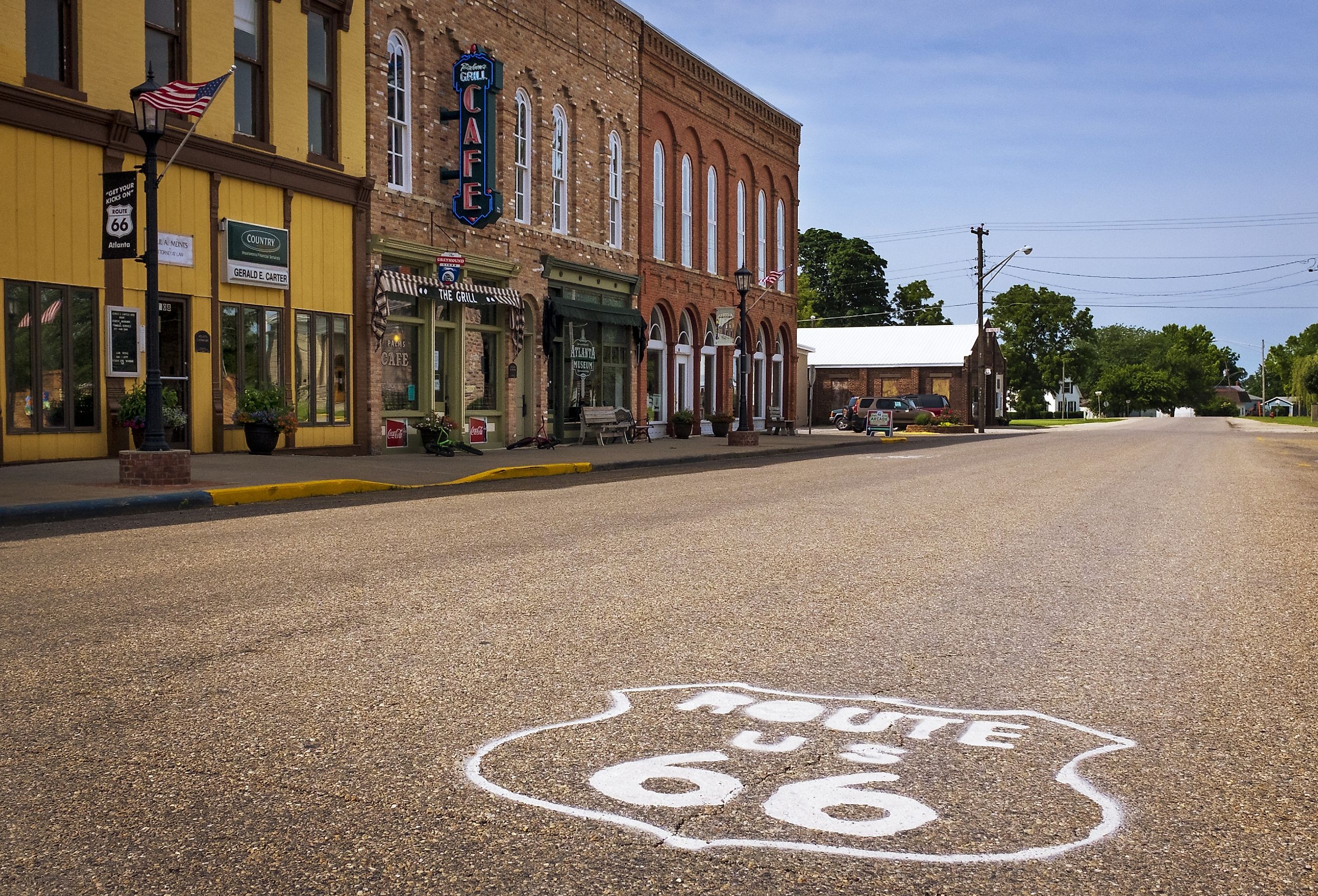
Route 66 Scenic Byway

The Illinois stretch of Route 66, the "Mother Road," runs from Chicago to St. Louis, spanning approximately 300 miles. It’s a journey through nostalgia, with stops at roadside diners, quirky museums, and landmarks that evoke mid-century Americana. This route offers a deep dive into the culture and history of the American road trip, with attractions that span decades of automotive and cultural history.
Pontiac is a key stop, home to the Route 66 Hall of Fame and Museum, where murals and exhibits celebrate the highway’s history. In Litchfield, the Ariston Café, one of the oldest restaurants along Route 66, serves as a living monument to the road's culture, while the Litchfield Museum adds context to the town's connection to the highway. At the end of the Illinois journey, the Chain of Rocks Bridge is a unique perspective on Route 66, with its famous bend over the Mississippi River and views of the St. Louis skyline.
Starved Rock State Park Road Trip

Starved Rock State Park entrance, Illinois. Editorial credit: Sanya Kushak / Shutterstock.com
A road trip to Starved Rock State Park typically begins in the Chicagoland area and spans roughly 100 miles west to the park near Utica, Illinois. Known for its dramatic canyons, waterfalls, and hiking trails, Starved Rock is one of Illinois’ most popular outdoor destinations. The trip is an ideal mix of nature, history, and small-town vibes. It’s a perfect weekend getaway that immerses travelers in the natural beauty of Illinois.
Stop at Matthiessen State Park for a taste of the region’s canyons and waterfalls, with its less-crowded Dells area providing a peaceful alternative to the more popular Starved Rock. Just outside the park, the town of Utica is worth a visit for its local charm and history, including the LaSalle County Historical Museum and its connection to the Illinois and Michigan Canal. Starved Rock itself is the trip's centerpiece, with 13 miles of trails winding through glacially-carved canyons, leading to waterfalls like those in French Canyon and impressive overlooks such as Lover’s Leap.
The Lincoln Highway

The Lincoln Highway in Illinois runs 179 miles from the Indiana border near Lynwood to the Iowa state line at Fulton. As the first transcontinental highway, it played a crucial role in connecting small towns across the country. Driving this stretch gives travelers a sense of early 20th-century American road travel and highlights key historical towns along the way, making it a meaningful journey for history enthusiasts and road trip lovers alike.
A quaint stop is Dixon, home to the Ronald Reagan Boyhood Home, where visitors can explore the early life of the former president. Ashton has a unique Lincoln Highway interpretive site with its iconic “Gazebo,” where travelers can learn about the road’s impact on local communities. Finally, Fulton’s Dutch Windmill and Riverfront Park are a historical endpoint at the Mississippi River, connecting the highway’s history with the region’s rich immigrant heritage.
Meeting of the Great Rivers Scenic Byway

The Meeting of the Great Rivers Scenic Byway spans 33 miles along the Mississippi River, Missouri River, and Illinois River, beginning in Alton and stretching to Pere Marquette State Park. This route follows the natural river systems that have shaped Illinois’ landscape.
A must-see stop is the Lewis and Clark State Historic Site in Hartford, where visitors can explore the replica of Camp River Dubois, the starting point of the explorers' journey. Grafton has a charming river town atmosphere, with opportunities for riverboat cruises at Grafton Harbor to experience the convergence of the rivers firsthand. Another important stop is the National Great Rivers Museum in East Alton, which highlights the engineering and environmental impact of the Mississippi River through interactive exhibits and a guided tour of the adjacent Melvin Price Locks and Dam.
Ohio River Scenic Byway

The Ohio River Scenic Byway runs 188 miles along Illinois’ southeastern border, from New Haven to Cairo, following the path of the Ohio River. This route shows a glimpse into early American commerce and the role the river played in shaping both the economic and cultural history of the region. The byway connects small towns that were once vital to river trade, making it a drive rich in historical significance.
Key stops include Cave-in-Rock State Park, where travelers can explore the massive cave that once served as a hideout for river pirates. Elizabethtown’s Rose Hotel, built in 1830, is a window into 19th-century river travel, and we recommend you take a walk through its historic district. Another notable stop is Fort Massac State Park in Metropolis, where visitors can explore a reconstructed 1802 fort. It looks into the region’s military history and its strategic location along the Ohio River.
Cahokia Mounds Road Trip

The Cahokia Mounds road trip begins in Collinsville, Illinois, and takes travelers through the heart of one of the largest prehistoric Native American civilizations north of Mexico. The Cahokia Mounds State Historic Site spans over 2,200 acres and contains 80 remaining mounds from the original city, which was at its peak around 1100 AD. This road trip is an opportunity to explore the remnants of this advanced society and gain insights into its archaeological significance, all within the boundaries of Illinois.
An intriguing stop is Monks Mound, the largest earthen structure in North America, towering 100 feet and boasting panoramic views of the site. The Interpretive Center, another key feature, presents exhibits, dioramas, and artifacts that illuminate the daily lives and achievements of the Cahokian people. Finally, a visit to Woodhenge, a reconstructed solar calendar, shows how the Cahokians tracked astronomical events.
Shawnee National Forest Scenic Drive

The Shawnee National Forest Scenic Drive is a network of routes winding through the southernmost part of Illinois, primarily along highways like Routes 45, 145, and 146, but it does not follow a single road. This drive typically begins in Harrisburg, Illinois, and ends near the town of Elizabethtown, covering over 280,000 acres of diverse forestland between the Mississippi and Ohio Rivers. The route showcases the natural beauty of the Shawnee National Forest, passing through dense woods, rock formations, and quiet rural areas.
One important stop along the drive is the Garden of the Gods Observation Trail, where visitors can walk among sandstone formations that have been shaped by millions of years of erosion. Another important stop is at the Bell Smith Springs Recreation Area, where hikers can explore a series of deep canyons, natural stone bridges, and springs. Lastly, Rim Rock Trail is another chance to delve into the forest’s diverse geological features, leading visitors through bluffs and into cool, shaded woodlands.
Illinois Covered Bridges Road Trip

An Illinois Covered Bridges Road Trip typically starts in the town of Chatham and ends in Princeton, taking travelers through the countryside of central Illinois. This route connects several historic covered bridges that date back to the 19th century, each with a well-preserved look into early American craftsmanship. The trip covers a large portion of the state’s rural landscape, making it ideal for those looking to explore Illinois’ history while enjoying a peaceful drive through the countryside.
An interesting stop is the Sugar Creek Covered Bridge near Chatham, built in 1880 and spanning 60 feet across the creek. The Cumberland County Covered Bridge, another key stop, was originally built in 1886 and later reconstructed. It is a picturesque setting for photos and exploration. A stop at the Red Covered Bridge in Princeton is where you want to go to see one of the state’s oldest covered bridges, dating back to 1863, and to enjoy the surrounding countryside that has changed little since the bridge’s construction.
Explore Illinois, One Road Trip at a Time
Whether you're interested in exploring Illinois' nature, historical significance, or a bit of both, there’s a road trip for everyone. The Great River Road offers a sweeping 550-mile journey along the Mississippi River, where you can experience the charm of towns like Galena and the historical importance of river commerce in Cairo. For those more nostalgic for the golden age of American road trips, Route 66 takes you on a journey through mid-century Americana, with quirky museums, roadside diners, and iconic landmarks. Lastly, if you're seeking an escape into nature, the Starved Rock State Park Road Trip immerses you in dramatic canyons, waterfalls, and the quaint town of Utica. Each road trip in Illinois invites travelers to discover the diverse stories that have shaped the state, from its ancient past to its role in modern American history.


