Visit The Site Of North America's Deadliest Rockslide

Canada is a vast country with a storied history. Given its sheer size (the second largest country in the world by landmass), it has its fair share of wild lands, from the dense forest of the east to the extensive mountain ranges in the west. For any growing country, this also means vast amounts of natural resources for the picking.
Around the turn of the 20th century, and less than two decades after the Canadian Pacific Railway was fully completed (spanning from Montreal to Vancouver), Canada's resource-extracting industries were in full swing. As you can probably imagine, the Rocky Mountains in western Alberta and eastern British Columbia were (and still are) ripe with many valuable minerals and ores, and the site of much of the economic action in the then-young country.
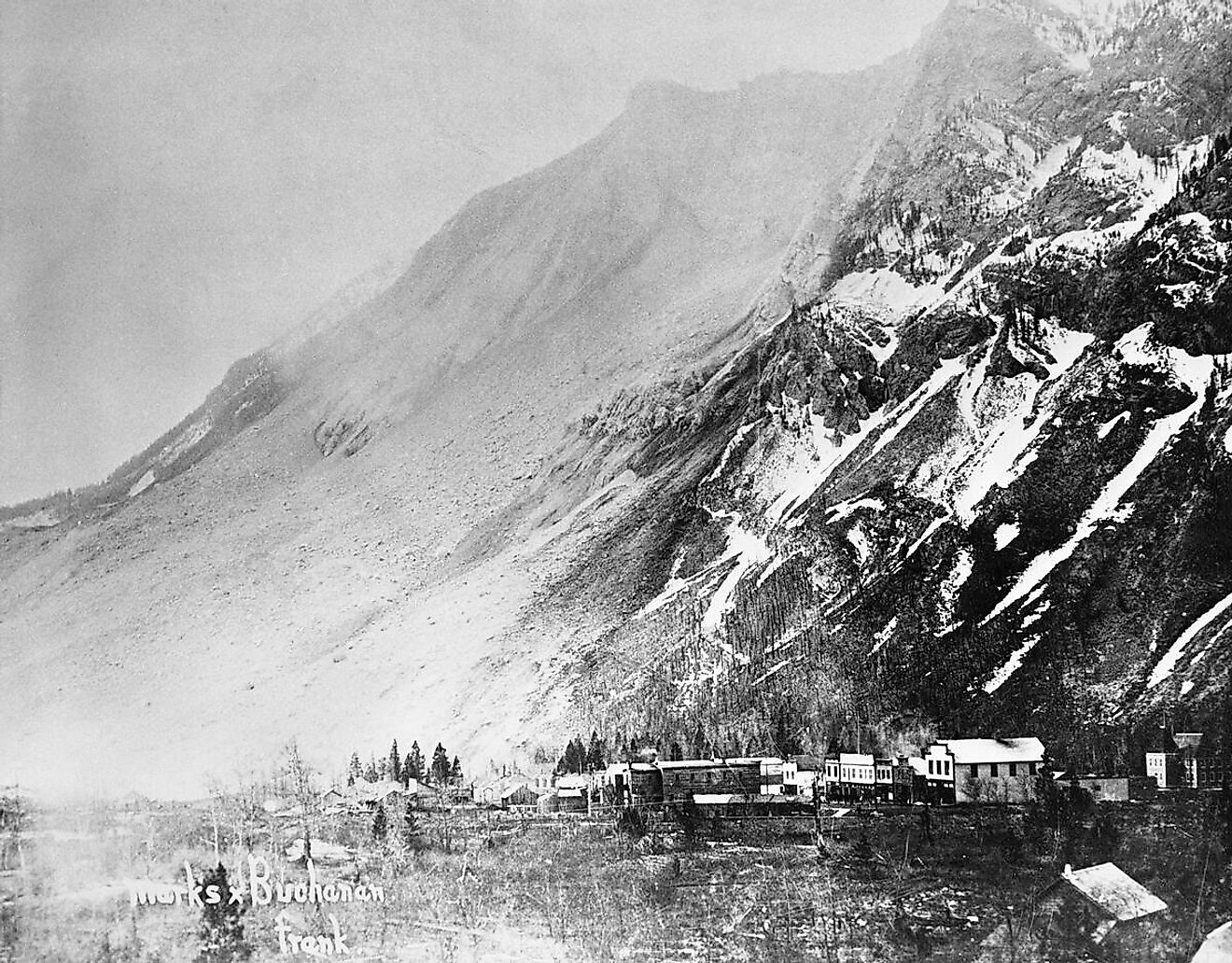
Frank, located in southwestern Alberta, was one of many towns across Canada that were established along the Canadian Pacific rail line after the discovery of an important resource, in this case, coal. Coal was the primary source of energy back in 1901 at the time of the town's founding, powering anything from trains and ships to home heating. Just 2 years later, Frank will also become the site of one of Canada's worst natural disasters, and to be exact- the worst rockslide in North American history.
The Early Days of Frank
The town of Frank gets its name from one of its founders, Henry Frank, an American who in 1901 helped develop the coal mines that were the primary drivers of its budding economy. Located in the Crowsnest Pass in southern Alberta, an important pass through the Rocky Mountains, Frank was just one of several towns established to serve the mines that were so prevalent in the region.
Some towns thrived off of gold, silver, iron, sandstone, zinc, or other types of ore/minerals, but the mines around Frank primarily extracted coal, and industry which still plays an important part in Alberta's economy. Around the time of Frank's founding, coal had a much more important place in the world before liquid gas and oil became the primary sources of energy powering the world. Because of this, Frank boomed, and by 1903 over 600 people called it home and dozens of permanent businesses and public services were established, including a vital regional post office and a school.
However, this period of good fortune would soon see a drastic and tragic speed bump.
The Frank Slide

At 4:10 AM on April 29th, 1903, the residents of Frank were awoken by loud rumblings coming from the nearby Turtle Mountain which towered over the town, rumblings that were so loud that they could allegedly be heard up to 200 kilometers away. In just over 100 seconds the history of Frank would change forever. 100 million tonnes of rock, primarily limestone, broke off from the mountain, seemingly cutting it in half, and rushed towards Frank so fast that most who were in its path had no chance of escape.
It is commonly said that the whole town was engulfed by the rock slide, when in fact, only a part of it was. 100 residents were caught in its path, 90 of which were killed. Of the dead, most were never recovered due to the sheer amount of rock that was piled on top of them, with some spots being covered in up to 150 feet of rubble! Most of the rubble was never cleaned up actually, and to this day, Highway 3, the main route passing through the area, was simply built on top of the rock pile, a bit of an unnerving thing to think about the next time you are driving over it.
Several buildings and pieces of infrastructure also fell victim to the slide, including most of the coal mining facilities nearby, 2 kilometers of the Pacific Canadian rail line, a number of miner's residences, a farm, a couple of ranches, and a handful of shops, among other things.
Why did the Frank Slide Happen?

Another common misconception of the Frank Slide was that it was caused by the extensive mining that was taking place within Turtle Mountain. While coal mining may have played a small part in the instability of the mountain, it was the way in which it was naturally formed that ultimately set it on a path towards its eventual collapse.
Most mountains around the world, including the ones in the Rockies, are formed by the upper layer of rock in the earth's crust crunching and rubbing together, causing it to thrust up or down, at times in very dramatic fashions. Imagine laying a blanket on the floor, then putting your hand on one corner and sliding it towards the middle. The blankets ahead of your hand will inevitably crumple/fold, causing the originally flat blanket to now feature ripples throughout. Now picture this on an earth-sized scale, and instead of a soft and pliable blanket, it is a crumbling layer of rock, the forces now moving it being the natural movement of the earth's tectonic plates over millions of years. This is a simplified version of how Turtle Mountain came to be.
Over time, the continuous movement of the rock layers (as well as water seeping into its crevices and expanding and contracting over eons of seasonal temperature changes), led to huge amounts of instability. The northern half of Turtle Mountain, which was hanging over Frank, gave way under its immense weight and ultimately led to the devastation event now called the Frank Slide.
What Does the Town Look Like Today?

As noted, only a portion of Frank was hit by the rock slide, in the east side of town more precisely. Because of understandable fears of another part of Turtle Mountain collapsing again, many people decided to shift toward the west side, heavily developing it to a point where the population grew to over 1,000 by the time 1910 came around. It was obvious that even an event like the Frank Slide was not enough to thwart the resilience of Frank's residents. More convincingly, there were still many riches to be made deep inside the hills around town, and the hunger of the growing Canadian economy had to be satiated.
Further studies into the stability of Turtle Mountain deemed almost the entirety of the original townsite to be within the path of another potential landslide, causing it to have to be moved further west into an area that many locals called "New Frank." "New Frank" (officially just called Frank) can still be visited today and is now a community within the larger Crowsnest Pass Municipality.
After Frank's Peak in 1910, a long period of market stagnation caused a decline in the growth of the town, and much of it was abandoned in the coming decades. As of 2021, its population stands at just 147. The actual site of the Frank Slide was designated a Provincial Historic Site of Alberta after having been deemed a National Historic Site in 1958.
Interestingly, a well-preserved piece of period architecture from Frank still stands today... 75 miles away in the town of Vulcan. The Imperial Hotel, which was once one of the main hotels serving guests to Frank, had been dismantled and moved to the central Alberta town in 1912 and renamed the "Vulcan Hotel", where it continued to function as a hotel and restaurant for some time. Unfortunately, as of the writing of this article, it does not seem to be in operation anymore, although you can still walk by it on the corner of 2nd Avenue and Centre Street.
Tourism at the Frank Slide

The morbid interest in the Frank Slide has since been the driver of a fairly robust tourism industry in the area. With an estimated 100,000 visitors annually, a very well-curated museum and visitor center have since been erected near the site of the disaster. With a small fee to enter the museum portion of the building, here, you can explore exhibits that feature artifacts found in the Frank Slide as well as ones that highlight the causes of the rock slide and the stories of both its victims and survivors. The Frank Slide Interpretive Centre also hosts a gift shop, seating, and various picnic areas outside of it.

The massive rubble pile the slide created also contains a network of trails over top of it, most of which are easily accesible near the parking lot of the visitor center.


