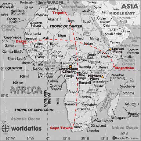
Geography Statistics of Africa

- Continent Size: 30,221,532 sq km, 11,668,599 sq miles
The only continent larger in area is Asia - Percent of Earth's Land: 12.7%
- Highest Point: Mt Kilimanjaro, Tanzania, 19,341 ft (5,895m) (see map)
- Lowest Point: Lake Assal, Djibouti (-512 ft) (-156 m) (see map)
- Geographic Center: The geographic center of Africa is located within Lobeke National Park in far southeastern Cameroon at 2° 37' N 16° 06' E. (see map)
- Horizontal Width: 4,355 miles (7,009 km) from Dakar, Senegal, east to Mogadishu, Somalia (see map)
- Vertical Length: 4,504 miles (7,248 km) from Cape Town, South Africa north to Tripoli, Libya: (see map)
Note: Lengths and widths are point-to-point, straight-line measurements and will vary some using other map projections.
Largest African Countries: (by land area)
- Algeria: 2,381,741 sq km
- Congo, DRC: 2,344,858 sq km
- Sudan: 1,861,484 sq km
- Libya: 1,759,540 sq km
- Chad: 1,284,000 sq km
- Niger: 1,267,000 sq km
- Angola: 1,246,700 sq km
- Mali: 1,240,192 sq km
- South Africa: 1,221.037 sq km
- Ethiopia: 1,104,300 sq km


