Rivers in North America - North American Rivers, Major Rivers in Canada Us Mexico - Worldatlas.com
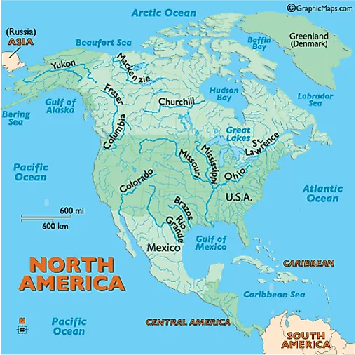
Hundreds of rivers and their tributaries slice across North America. Here we highlight the major ones, and offer a brief description.
Brazos: This Texas River begins in the northern part of the state in Stonewall County, and flows southeast into Brazoria County and the Gulf of Mexico. It's (840 miles) (1,351 km) in length.
Churchill: This river of central Canada rises in northwestern Saskatchewan, then flows east into Manitoba, and on into Hudson Bay. It passes through numerous lakes and is known for the rapids along its path. It's (1,000 miles) (1,609 km) in length.
Colorado: Beginning in the Rocky Mountains of northern Colorado, it moves southwest, ending in the Gulf of California. It's (1,450 miles) (2,333 km) in length and over the centuries formed numerous canyons along its winding path. The most famous of these is the Grand Canyon in northern Arizona. The river has more than 30 electric power plants along its run, as well as dozens of dams and reservoirs.
Columbia: This wide, fast-flowing river begins in the Canadian Rockies of southeast British Columbia, Canada, flowing south through the State of Washington, then forming the natural border between Washington and Oregon. It ends in the Pacific Ocean and is (1,152 miles) (1,857 km) in length. Hydroelectric power development in the river basin brought inexpensive electricity to the Pacific Northwest, but it severely affected salmon spawning and local fish migration.
show Landforms


