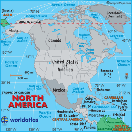
return to Graphic Maps

World Atlas including Geography Facts, Maps, Flags
dot
Africa | Antarctica | Arctic | Asia | Australia/Oceania | Caribbean | Central America | Europe | Islands of the World
Middle East | North America | South America | World Atlas | WIN $100 here


PRINT THIS MAP
Outlined Time Zones of North America,United States, and Canada - match the time bar color to the map color - dot Current Dates and Times
across North America....

Across much of North America, Daylight Saving Time (DST) is now in effect.

Daylight Saving Time is not observed in the U.S. states of Hawaii and Arizona, the Canadian province of Saskachewan, Central American countries, central and eastern Caribbean islands, and the Mexican state of Sonora.

Specific Times

To find the current date and time in a specific Canadian province or territory, Caribbean island, Central American country, Mexican state, or U.S state, we suggest you click on your area of interest.

Note: This map will change throughout the year to reflect any and all time changes.

dot UTC and GMT
an update....

The worldwide standard for coordinated universal time, formerly known as GMT (Greenwich Mean Time), is now abbreviated as UTC (Coordinated Universal Time).

Some sources still refer to it as UTC/GMT and some web browsers, I.E. Mozilla, still display it as GMT.

The UTC Time (shown directly below) is the standard time zone from which all other worldwide time zones are based upon. It never observes daylight saving time.

arrow UTC Time at Greenwich, England
arrow For additional details on worldwide time zones, please refer to this page.

HST -10 hours from UTC
Hawaii
AKDST - 8 hours from UTC (DST)
Alaska
PDT - 7 hours from UTC (DST)
western Canada, US and the northern Baja
MST - 7 hours from UTC
Arizona and Sonora, Mexico
MDT - 6 hours from UTC (DST)
west-central Canada, US and Mexico
SASK/CST - 6 hours from UTC
Saskatchewan
CST - 6 hours from UTC
Central America countries - not Panama
CDT - 5 hours from UTC (DST)
central Canada, US and most of Mexico
EST - 5 hours from UTC
Haiti, Jamaica, Panama, Turks & Caicos
EDT - 4 hours from UTC (DST)
eastern Canada and US, Bahamas, Cuba
AST - 3 hours from UTC
eastern Caribbean islands, most of Greenland
ADT - 3 hours from UTC (DST)
Bermuda, Labrador, New Brunswick, Nova Scotia
NDT - 2 1/2 hours from UTC (DST)
Newfoundland
HST (Hawaii Standard Time) AKDST (Alaska Daylight Time) PDT (Pacific Daylight Time) MST (Mountain Standard Time) MDT (Mountain Daylight Time)
CST (Central Standard Time) SASK/CST (Saskachewan Central Standard Time) CDT (Central Daylight Time) EDT (Eastern Daylight Time)
EST (Eastern Standard Time) ADT (Atlantic Daylight Time) AST (Atlantic Standard Time) NDT (Newfoundland Daylight Time)
Daylight Saving Time (DST)


Contact Us | Privacy Statement

Copyrighted by Graphic Maps
All rights reserved!

All maps, graphics, flags and original descriptions created by Graphic Maps, a d/b/a of the Woolwine-Moen Group, unless otherwise noted and/or directly linked to the source, and use of same for any application whatsoever (with the exception of outline maps) requires written permission.

We make no copyright claim on any statistical data on this page, nor on any non-original graphics, and/or pictures not produced by us. Certain statistical data is gathered from the CIA World Factbook, as well as numerous public domain reference materials.

Every effort is made to be as accurate as possible when disseminating information on any worldwide destination. We are not responsible for unintentional data entry errors or omissions. If you would like to submit an addition, change or correction, or suggest a new link, please forward it to our map department and we will give it our immediate attention.


return to Graphic Maps
World Atlas including Geography Facts, Maps, Flags
dot dot dot

search and find