Planning Your Mount Rainier Hike
Mount Rainier is possibly Washington State's most iconic symbol, jutting up into the clouds from just beyond the Seattle skyline. It's visible for hundreds of miles in nearly all directions. Standing at 14,410 feet, it is the tallest mountain in Washington and the Cascade Range. It also provides seemingly endless outdoor activities for all of its visitors, from simple sightseeing to luxury lodging options, campgrounds, and of course, lots of hiking, making Mount Rainier National Park among the most visited parks in the country.
Whether you seek to summit the peak or just want to embark on an easier day trip, here are some of the best ways to hike Mount Rainier you should consider the next time you visit.
Easier Day Hikes
Most people who visit Mount Rainier are looking to gaze upon its scenic natural beauty for an afternoon and head out before the sun goes down. If you're in the mood for easy-going trails with minimal sweat, there are plenty of great spots to check out. Here are a few top picks to consider.
Myrtle Falls

The southern face of the mountain is where most go to experience Rainier. Here, you will find the most convenient (although often crowded) parking, the Henry M. Jackson Visitor Center, and other useful amenities. Just under a mile's walk from the visitor center, in the aptly named "Paradise" section of the park, is Myrtle Falls. On a rare clear day, expect to see an unbeatable, close view of Mount Rainier's glacier-covered peak.
A charming footbridge crosses Edith Creek just above the falls, offering a stunning view of the glacier-fed cascade below, all at the end of this short trail.
Given the amount of rain the area gets, mixed with the water from the stream, around the falls is incredibly lush and verdant. A good time to go is mid-late summer when the alpine wildflowers in the surrounding meadows are blooming.
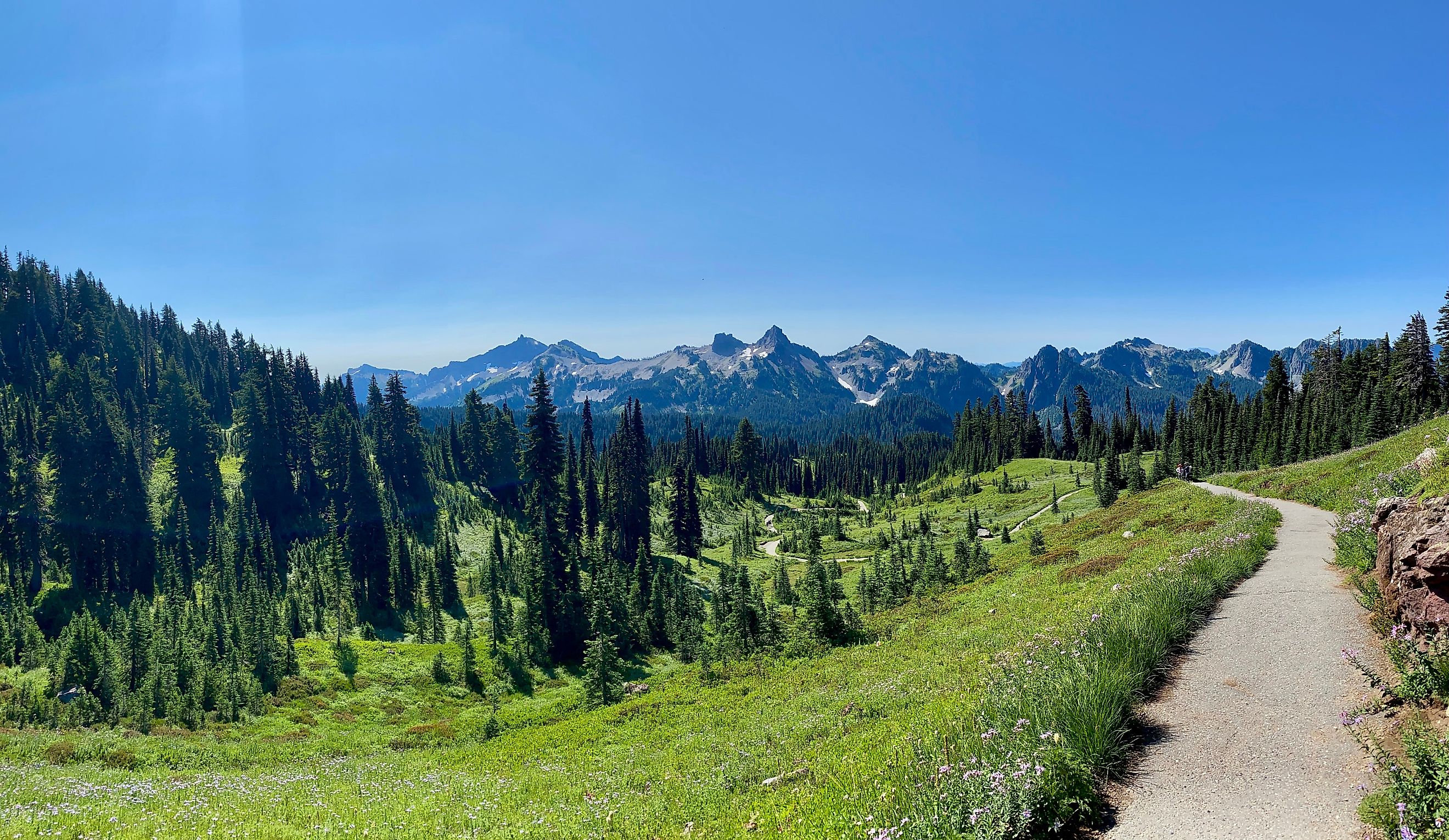
Skyline Loop

Around 6 miles long (depending on the route you take), the Skyline Loop trail system will lead you up to its climax at Panorama Point, named after its panoramic vantage point high above the forests and meadows of Mount Rainier National Park. Getting there requires a steep journey through changing landscapes. From the woodlands at the start of the trail to the alpine meadows and meandering streams around the middle, to the rocky outcrops at the top with clear views of some of Rainier's epic glaciers.
It features paved paths, rugged rock-covered trails, and snow-covered sections at the higher altitudes, so prepare accordingly. While Panorama Point is more often than not shrouded by clouds, you may get brief windows of clear skies to experience the views.
The Skyline loop may seem challenging, but its moderate length and abundance of scenic vistas make it manageable for most hikers. The parking lot and visitor center, complete with restrooms, a snack bar, and a gift shop, greet you at the end.
The trail offers a mix of terrains and ever-changing weather conditions, so being well-prepared is key. Equip with water, snacks, weather-appropriate clothing, and sturdy footwear to navigate the challenges ahead. This ensures a safer, more comfortable hike, no matter what the trail throws your way.
Mazama Ridge

Starting along Valley Road, just east of Paradise, is an out-and-back trail leading to Mazama Ridge. A grassy ridgeline on the mountain's southern face that will take you through an amazing array of scenery, from flower-filled meadows to glacial lakes and rocky outcrops. Here, you may find less crowded viewpoints of Rainier's peak.
Nearly 4 miles in length, and with about 1,100 feet of elevation gain (mostly at the beginning), this trail is a bit of a thigh burner, but short enough to feel totally rewarding once you get to the top of the ridge.
As the sunset unfolds, vibrant colors of wildflowers and rich greenery, framed by patches of lingering snow, create a breathtaking alpine landscape. The scene is almost otherworldly, creating a moment of pure awe in nature’s splendor.
Mowich Lake

Located on the lesser-visited northwestern face of Rainier, you can drive all the way to Mowich Lake via the Mowich Lake Road. It is accessible through the small town of Carbonado, which lies just southeast of Tacoma.
As one of the largest lakes in and around the mountain, it makes for a great spot to have a picnic by the water and soak in the sights. A campground is situated steps away from its shores if you wish to stay the night.
Walk partway around the lake along sections of the larger Wonderland Trail, or explore the surrounding area on the network of paths sprouting out from the lake's nearby parking lot. Head north about 5.6 miles and summit the famous Tolmie Peak, a non-technical hike that will provide you with a lofty view directly above Eunice Lake. You can also take a walk southeast from the campground along the 7-mile Spray Park Trail. The latter is a tough yet doable hike that passes by clusters of towering evergreen forests, an assortment of waterfalls, and some of the best wildflower meadows in the entire park.
Walking All the Way Around

It is possible to circumnavigate Mount Rainier along one single route, the Wonderland Trail. Spanning about 93 miles in length and featuring an astounding 27,000 feet of total elevation gain and loss, this trail is not recommended for beginners. Although no section of it requires technical mountaineering skills, it takes 1 to 2 weeks to complete. The trail crosses moving water at certain points, and if the winter snow has not fully melted yet, you could potentially encounter expanses of snow crossings too.
Hikers commonly commence the trek in Longmire, a historic district you will see if driving in via the Paradise Valley Road. You can also start near Sunrise on the northeastern face, the Mowich Lake Campground, or various other points along the way that intersect with other trails. If you have the energy to extend your hike, the Wonderland Trail also comes across several other scenic side routes, like Box Canyon, Reflection Lake, and Carbon Glacier/Moraine Park. A sizable portion of Wonderland Trail also doubles over the Spray Park Trail.
A map of the area, adequate food, a water filtration system, good hiking gear, and basic backcountry skills is the minimum needed to complete the Wonderland Trail. Be aware that backcountry camping here also requires a wilderness permit. These permits are usually in very high demand, so be sure to reserve one early.
Summiting Mount Rainier

Although still relatively dangerous, summiting Mount Rainier is actually considered somewhat easier (at least in technical climbing terms) when compared to other mountains of similar size. Few portions of the journey require technical alpine climbing, for instance. Known for its massive glaciers, unpredictable weather, and glacial routes, getting to the top of Mount Rainier is still not a casual hike but a serious endeavor.
Travelers typically ascend via the Disappointment Cleaver or Emmons Glacier routes, both requiring proper gear, glacier travel skills, and excellent physical conditioning. Guided expeditions are common, especially for first-timers, as they provide essential training and greatly improve the chances of a safe and successful journey.
The trip usually spans two to three days. You will likely spend a night at camps, such as Camp Muir or Camp Schurman, before making an early-day push towards the summit. Weather on Mount Rainier can shift rapidly, with storms rolling in unexpectedly, making timing crucial.
A successful summit will offer you views of the region that you simply can't get anywhere else, stretching to Mount Adams, Mount St. Helens, and even Mount Hood on clear days.
Accommodations at Mount Rainier

Making the journey back to the city is often a daunting task after a tough day out in the mountains. Just steps away from some of Rainier's best trailheads at Paradise is one of America's most iconic lodges, The Paradise Inn. With luxury rooms and high-end dining options, it is a lavish way to end your outdoor adventure. Even if you can't get a room here, the Inn's gorgeous architecture and wonderful interior are still worth checking out.
Nearby Longmire is home to the National Park Inn, while further south, the town of Packwood has a number of hotels, inns, and rentals available for more budget-conscious travelers as well.
As with many parks, camping is plentiful here, too. On the north face of the mountain, you will find White River Campground near the Sunrise area, or for some light backcountry camping, the Sunrise Walk-In Camp. Mowich Lake Campground is a pleasant and very accessible campground if you're coming in from Tacoma or Seattle. And should you want to stay closer to the action in southern face, Cougar Rock Rock Campground is a sizable facility just off of Paradise Valley Road.