Ionian Islands
The country of Greece comprises several islands. Depending on their location, these islands are further grouped into clusters such as the Dodecanese, Cyclades, Sporades, Crete, North Aegean, the Argo-Saronic, and the Ionian Islands.
The Ionian Islands are a group of islands that are located off the western coast of Greece in the eastern part of the Ionian Sea. Collectively, the Ionian islands occupy a total land area of 2,306.94 km2 and comprise seven major islands and several smaller islands. These islands are also often referred to as “Heptanese” or “Seven Islands.”
Geography
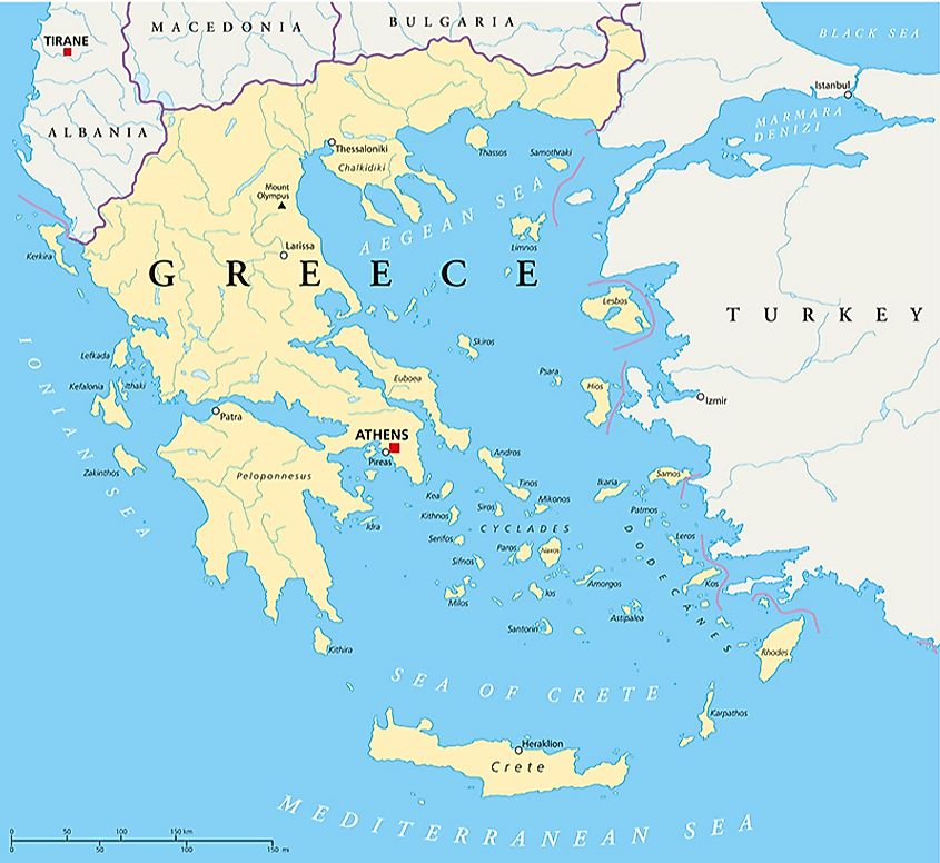
The major islands in the Ionian Island group include Kerkyra (Corfu), Paxi, Lefkada, Ithaki, Kefalonia, Zakynthos, and Kythira. The Ionian Islands became a part of Greece in 1864 and all the islands except Kythira belong to the Ionian Islands Region. Kythira island, which is located on the southern edge of the Peloponnese Peninsula, belongs to the Attica administrative region of Greece.
Kefalonia/Cephalonia

Kefalonia/Cephalonia is the largest among all the Ionian islands. Mount Ainos, which rises to an elevation of 1,628 m, is the highest point on the Ionian Island. A major part of the Ainos Mountain range is dominated by trees such as Greek fir and Black pine and has been designated as a National Park. Located on the island’s eastern side is Argostoli, which serves as the capital, administrative center, and the principal port of Kefalonia. The island hosts the endangered loggerhead turtles that are colloquially known as Caretta caretta turtles. More than 200 avian species have also been reported from the Kefalonia island.
Corfu/Kerkyra

Located in the northern part of the Ionian Sea, the Greek island of Corfu is a well-known Ionian island. Corfu is dominated by rugged mountains in the north and Pantokrator Mountain is the island’s highest point which reaches an elevation of 911 m. Located on a peninsula in the eastern part of the island is Corfu, the capital, principal city, and chief port of Corfu island. The city's Old Town has been designated as a UNESCO World Heritage Site since 2007.
Lefkada

Located in the heart of the Ionian Sea, the island of Lefkada is connected to the mainland by a floating bridge. Located in the center of the island is Mount Stavrota, which rises to an elevation of 1,158 m and is the highest point on the Lefkada island. The island’s main town, Lefkada, is located in the northeastern part of the island. There are many resorts on the eastern coast of the island.
Brief History

Due to the strategic location of the Ionian Islands between the mainland of Greece and Italy, the islands and their inhabitants have suffered a lot of outside interventions since ancient times. In the fourth century BCE, the islands became a part of the Macedonian Empire. In 146 BCE, the entire Greek peninsula was annexed by the Roman Empire. After the Roman Empire was split, the islands formed a part of the Byzantine Empire. From the late 11th century, the islands were frequently targeted by the Normans and the Italians. From 1204, the Ionian Islands came under Venetian rule. The Venetians prevented the islands from becoming a part of the Ottoman Empire. In 1797, Venice was conquered by Napoleon Bonaparte, and by the Treaty of Campo Formio, the Ionian islands were ceded to France.
In 1798, the French were evicted from the island by the Russian Admiral Ushakov, who also established the Septinsular Republic. However, by the Treaty of Tilsit in 1807, the Ionian Islands were once again handed over to the French. After the defeat of the French forces by the British Royal Navy, the islands were placed under the protection of the British by the 1815 Treaty of Paris. In 1864, the islands were presented as a gift by the British to the new Greek King, George I. the islands were, however, occupied by Italy in 1923, and during the Second World War they were occupied by the Germans. Together with the rest of Greece, the Ionian Islands were liberated in 1944.

